
CALIFORNIA, USA — Just like two years of drought conditions led to record wildfire outbreaks, so too did California’s extreme variability in weather lead to heavy storm conditions.
California is often noted as the state with plenty of sunshine and very little weather, but the roller coaster that is California weather continues to surprise residents of the state as well as meteorologists and climatologists.
The last two years brought record drought to the state and some of the worst wildfires ever recorded in state history. Nearly half of the state's 20 largest wildfires occurred in 2020 and 2021. Fire crews were no match for the drought conditions that endured. It took months to contain fires, only to see strong wind event reignite fires once again.
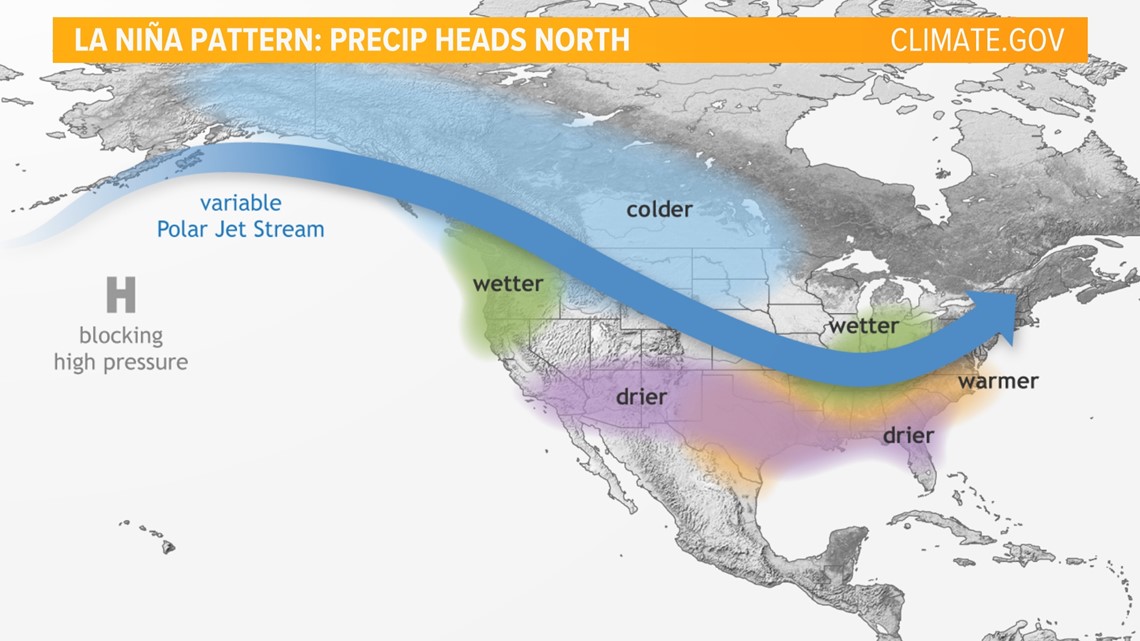
The central and northern California regions often get put into major predicaments when it comes to climate patterns. The El Nino southern-oscillation (ENSO) is a climate pattern that reflects the temperature differences in our oceans over the year. Some are probably familiar with the terms "an El Nino year, or a La Nina year." These terms are a way for climatologists to try and predict what kind of rainy season we'll see.
A La Nina year typically means cooler than average sea surface temperatures in the central and eastern Pacific. The cooler temperatures for our coast line usually indicates cooler temperatures and less precipitation. Meanwhile, much warmer conditions and heavier rain is seen in Indonesia and the western Pacific.
A high pressure system forms over the central Pacific, blocking storms and pushing the jet stream over the ocean before these storms have a chance to move into California. The warm air in Indonesia is usually lifted as a low pressure system moving up and over the Pacific and targeting the Pacific Northwest. That frequently means less rain for California.

The two years of drought have been recorded as La Nina years. Many try to pin an "El Nino" year or "La Nina" year to the lack of rain or excess, but often, the rules don't always apply to more than half the state of California.
What La Nina doesn't often account for is the atmospheric rivers. These warm, long bands carry moisture for hundreds of miles providing necessary water to California.
Marty Ralph, with the Center for Western Weather and Water Extremes says "these atmospheric rivers can carry as much as 27 times the amount of water flowing through the mouth of the Mississippi River."
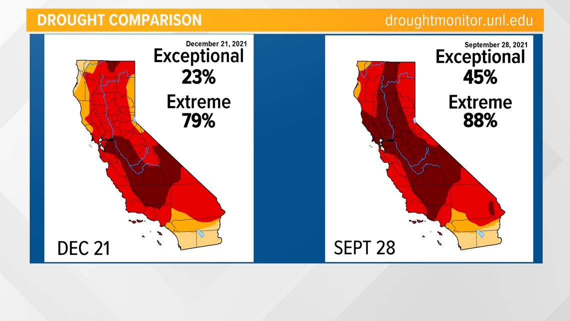
This La Nina year has seen storm after storm tap into an atmospheric river. This December has brought in record rain and snow totals causing our drought conditions to be alleviated. While not completely gone, the drought has improved.

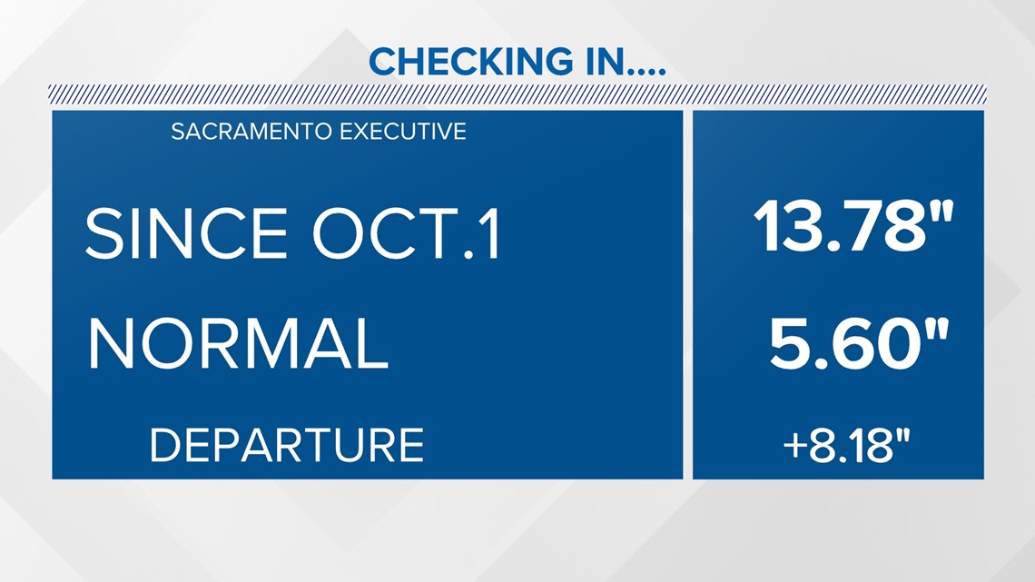
The state's exceptional drought status was nearly cut in half by more than double the average precipitation California gets this time of year. Sacramento received 13.78" of rain since the start of the water year on Oct. 1. It normally averages 5.60" by the end of December. The abundance of rain is thanks to atmospheric rivers.

Many are familiar with Pineapple Expresses. They are the most common form of atmospheric rivers originating near the Hawaiian Islands. The warm waters create heat and moisture. As that moisture rises and builds, it's funneled into a long band with the help of wind currents. The atmospheric rivers are then pushed toward the western U.S. It's not always obvious how high in latitude they'll land, but with just the right conditions, they can target northern California. If California can get numerous rivers with substantial precipitation, it can very well keep the state out of drought.

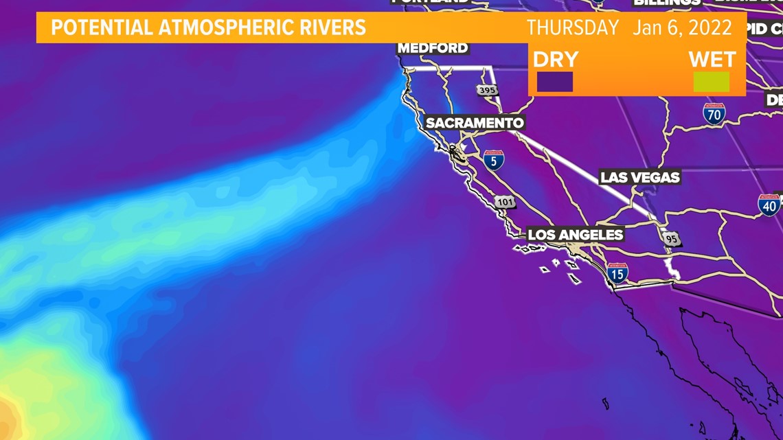
This doesn't always happen. The lack of atmospheric rivers targeting northern California is what typically leads to extreme drought. That's because the state relies heavily on atmospheric rivers for significant rainfall rather than solely relying on low pressure systems to carry that rainfall.
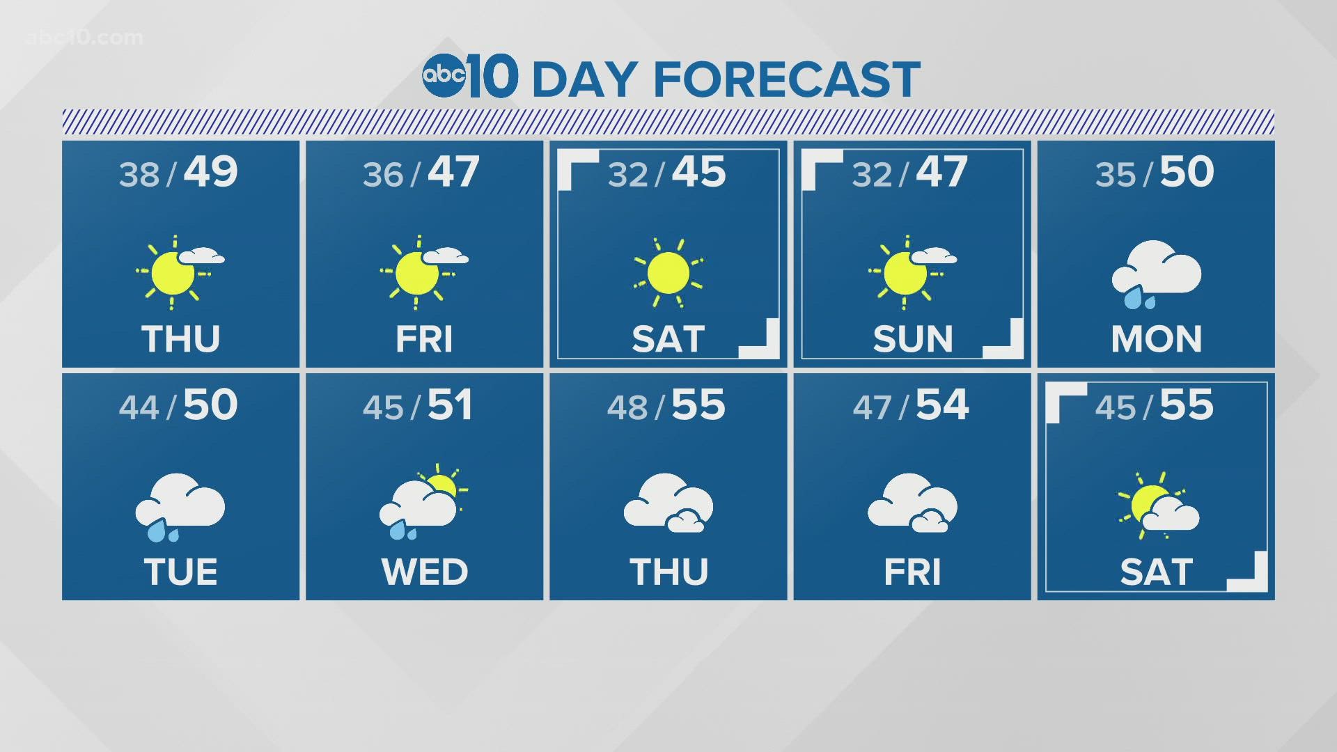
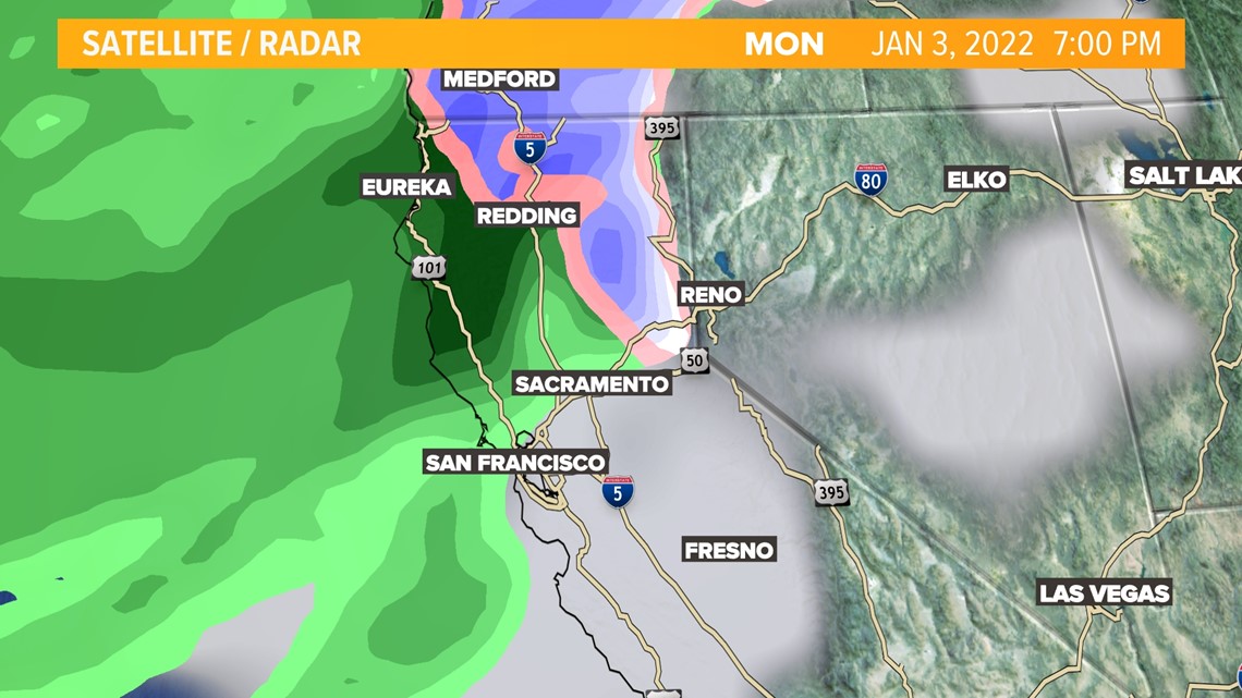
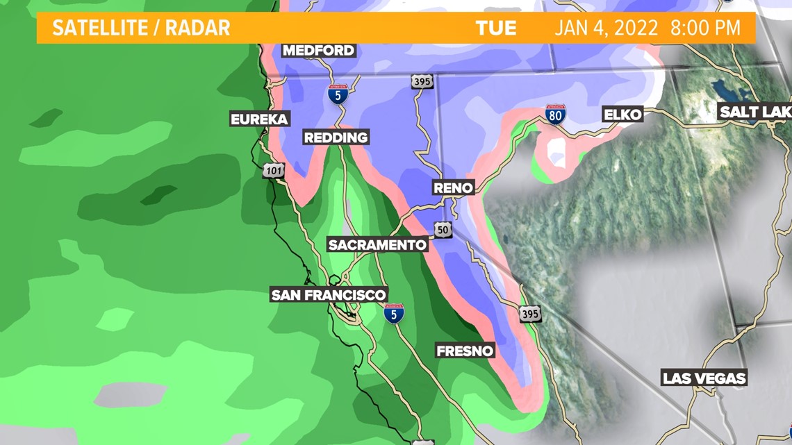
More wet weather is in the forecast for the start of the new year. A winter storm is set to arrive Monday, Jan. 3 bringing more rain to the valley and snow to the Sierra. If the pace continues with the current precipitation through the rainy months, northern California may be able to surpass the average Sacramento rainfall totals of over 19 inches per year.


WATCH ALSO:


