SACRAMENTO, Calif. — An excessive heat watch goes into effect Friday night, kicking off the weekend and a week long stretch of triple-digit temperatures in Northern California.
As an upper-level, high pressure weather system builds into the Central Valley, we will experience some of the hottest temperatures of the summer.
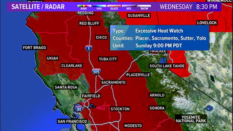
Because of the extreme heat during the day and warm overnight lows, the National Weather Service has issued an Excessive Heat Watch from noon Friday until 9 p.m. Sunday, Aug. 16. The hottest temperatures are expected Friday and Saturday with afternoon highs of 105°.
Bear in mind, normal daytime high for this time of the year is 92°.
Forecasted highs Thursday - Sunday:
Thursday: 101°
Friday: 105°
Saturday: 105°
Sunday: 102°
Unfortunately, long-range weather models are showing triple-digit temperatures well past this weekend. ABC10's 10 day forecast shows 100-degree temperatures through next Friday, Aug. 21.
If this forecast holds true, this will be the hottest stretch of 100° temperatures we've seen all summer. During this stretch of heat, it is important to remember to drink plenty of fluids and avoid outdoor activities during the hottest times of the day, between 10 a.m. and 6 p.m.
RELATED WEATHER ARTICLES:
► RAIN OR SHINE? GET THE LATEST FORECAST IN YOUR NEIGHBORHOOD BY DOWNLOADING OUR APP:


►Get the forecast in your email! Sign up now for the Daily Blend Newsletter
Watch more: