

EL DORADO COUNTY, Calif. — Click HERE for Wednesday's story on the Caldor Fire.
According to Operations Section Chief Eric Schwab, firefighters could try to steer the Caldor Fire into the Tamarack Fire in order to stop its spread.
"It’s a fresh burn and if we get it steered into there, whatever portion we get turned into it, that basically stops the spread of the fire. That’s a very valid tactic that we’re actively trying to do,” Schwab said during a 5 p.m. update.
The Kirkwood area has drawn the attention of firefighters. Schwab said the fire hasn't reached Kirkwood proper at this time, but it has been active east of the area. 20 fire engines are in Kirkwood doing preparations to defend structures if it reaches the area.
Standing guard are fire crews from LA County, Ventura County, Oxnard and more from across the state. Crews on scene said the winds have not pushed the fire over the ridge of the hill, but they're staying ready in case things change.
The herding tactic that could steer the Caldor Fire into the Tamarack Fire was used recently for the town of Strawberry and is also planned for Heavenly Mountain Resort. Schwab noted that Heavenly resort is still standing at this time. Crews plan to put in a dozer line between structures and the fire in order to herd it away.
“We can’t control it. It’s just we don’t have any tools out there to stop the fire, so we resort to herding the fire away from structures and away from people and that’s what we’re actively doing,” Schwab said.
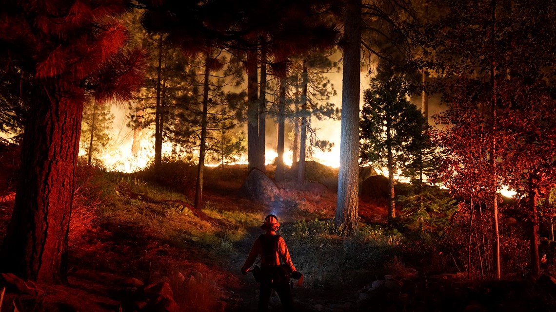
The Caldor Fire continued to moving east as more than 53,000 people were forced to evacuate across three counties. A California fire spokesman said the blaze was 3 miles outside South Lake Tahoe. The wildfire burning in El Dorado County has impacted communities in Amador and Alpine counties with evacuations. According to the Amador County Sheriff's Office, the fire has also made its way into Amador County, east of Silver Lake.
Communities just across the state line in Nevada were warned to get ready to leave, and Tuesday afternoon, portions of Douglas County were told to leave their homes due to the raging wildfire.
The fierce nature of the Caldor Fire was on display as it moved down a hill toward homes on the outskirts of South Lake Tahoe. Defensible space around some homes has proved to be a saving grace – keeping the fire at bay about eight to10 feet away. Firefighters say defensible space like these helps slow the fire down.

The Caldor Fire joined the list of largest wildfires in state history on Monday. New firefighters arrived Monday evening and were dispatched immediately to protect homes.
The National Weather Service also expanded the expiration of a Red Flag Warning to 11 p.m. Wednesday for the greater Lake Tahoe/Truckee area.
The fire has grown to 199,632 acres and is only 18% contained. More than 600 structures have been destroyed and at least 33,000 are threatened by the fire.
Evacuations and Road Closures
Click HERE for in-depth evacuation orders and warnings in El Dorado County. For evacuation orders and warnings in Amador County, click HERE for the Amador County Sheriff's Facebook page and HERE for their website. For current state highway/route information visit roads.dot.ca.gov.
Evacuation centers
El Dorado County Shelters
- Green Valley Community Church, Placerville
- Cameron Park CSD, Cameron Park
- Rolling Hills Church, El Dorado Hills
Nevada County Shelter
- Truckee Veterans Hall, 10214 High St, Truckee
Amador County
- Temporary Evacuation Point Italian Picnic Grounds, Sutter Creek
Nevada State Shelter
- Reno/Sparks Convention Center at 4590 S. Virginia Street, Reno
- Douglas County Community Center, Gardnerville - At Capacity
- Carson City Community Center, Carson City - At Capacity
- Carson High School, Carson City - At Capacity
Animal Evacuation Centers:
- El Dorado County Animal Services (small animals), Diamond Springs. For animal evacuation questions or assistance call (530) 621-5795
- Saureel Vineyards (large animals), Placerville - FULL
- Amador County Fairgrounds (large animal)- for Amador County residents only, Plymouth
- Italian Picnic Grounds in Sutter Creek
- Douglas County Animal Services (small animal), Gardnerville. (775) 782-9061
- East to West Coast Grooming, Gardnerville. (775) 450-1743
- Douglas County Animal Services (livestock) Douglas County Fairgrounds, Gardnerville. (775) 782-9061
Accounts to follow
Evacuation Maps
A map of evacuations from the El Dorado County Sheriff's Office is available below.
An evacuation map from the Amador County Sheriff's Office can be viewed HERE.
A map of evacuations in Alpine County is available below.
Wildfire map
Click here for a map of the Caldor Fire.
►Stay in the know! Sign up now for the Daily Blend Newsletter
What questions do you have about the latest wildfires? If you're impacted by the wildfires, what would you like to know? Text the ABC10 team at (916) 321-3310.
Wildfire Preps
If you live in a wildfire-prone zone, Cal Fire suggests creating a defensible space around your home. Defensible space is an area around a building in which vegetation and other debris are completely cleared. At least 100 feet is recommended.
The Department of Homeland Security suggests assembling an emergency kit that has important documents, N95 respirator masks, supplies to grab with you if you’re forced to leave at a moment’s notice. The agency also suggests signing up for local warning system notifications and know your community’s evacuation plans best to prepare yourself and your family in cases of wildfires.
Some counties use Nixle alerts to update residents on severe weather, wildfires, and other news. To sign up, visit www.nixle.com or text your zip code to 888777 to start receiving alerts.
PG&E customers can also subscribe to alerts via text, email, or phone call. If you're a PG&E customer, visit the Profile & Alerts section of your account to register.


