
EL DORADO COUNTY, Calif. — Click HERE for Monday's update on the Caldor Fire.
The eastward marching Caldor Fire has prompted evacuation orders in Amador, Alpine, and El Dorado counties.
Just after 9 p.m., an evacuation warning was issued for the Lake Tahoe Basin, from the Alpine/El Dorado county line, north along the California/Nevada state line to Lake Tahoe. This includes the city of South Lake Tahoe.
The area also includes the area north along the water's edge to the El Dorado/Placer co and west along the El Dorado/Placer county line to McKinney Lake.
As a reminder, according to the California Office of Emergency Services (Cal OES), evacuation warnings and evacuation orders are defined as the following:
- Evacuation Warning: Potential threat to life and/or property. Those who require additional time to evacuate, and those with pets and livestock should leave now.
- Evacuation Order: Immediate threat to life. This is a lawful order to leave now. The area is lawfully closed to public access.
Residents evacuating from the South Lake Tahoe area can seek shelter in Nevada at the Douglas County Community Center located at 1329 Waterloo Lane in Gardnerville.
Due to the warning in South Lake Tahoe, Barton Memorial Hospital decided to evacuate all its patients to regional partner facilities. The hospital's emergency department will remain open.
Containment decreased on the Caldor Fire down to 13% contained from 19%, Cal Fire said in an update shortly before 8 p.m. The fire has grown to 168,387 acres in size as of Sunday evening.
The Amador County Sheriff's Office issued the orders Sunday afternoon and is doing door-to-door evacuations in Silver Lake and Kirkwood areas.
The evacuation order applies to south of Highway 88 along the Amador/El Dorado County line from Dufrene Road, due east to the Amador/Alpine County line, and from the Amador/Alpine County line north to Highway 88.
An evacuation map from the Amador County Sheriff's Office can be viewed HERE.
Law enforcement and fire crews began staging at the Kirkwood resort as mandatory evacuations were issued there and for the Silver Lake area. Large pieces of ash were reportedly falling from the sky around 5:30 p.m.
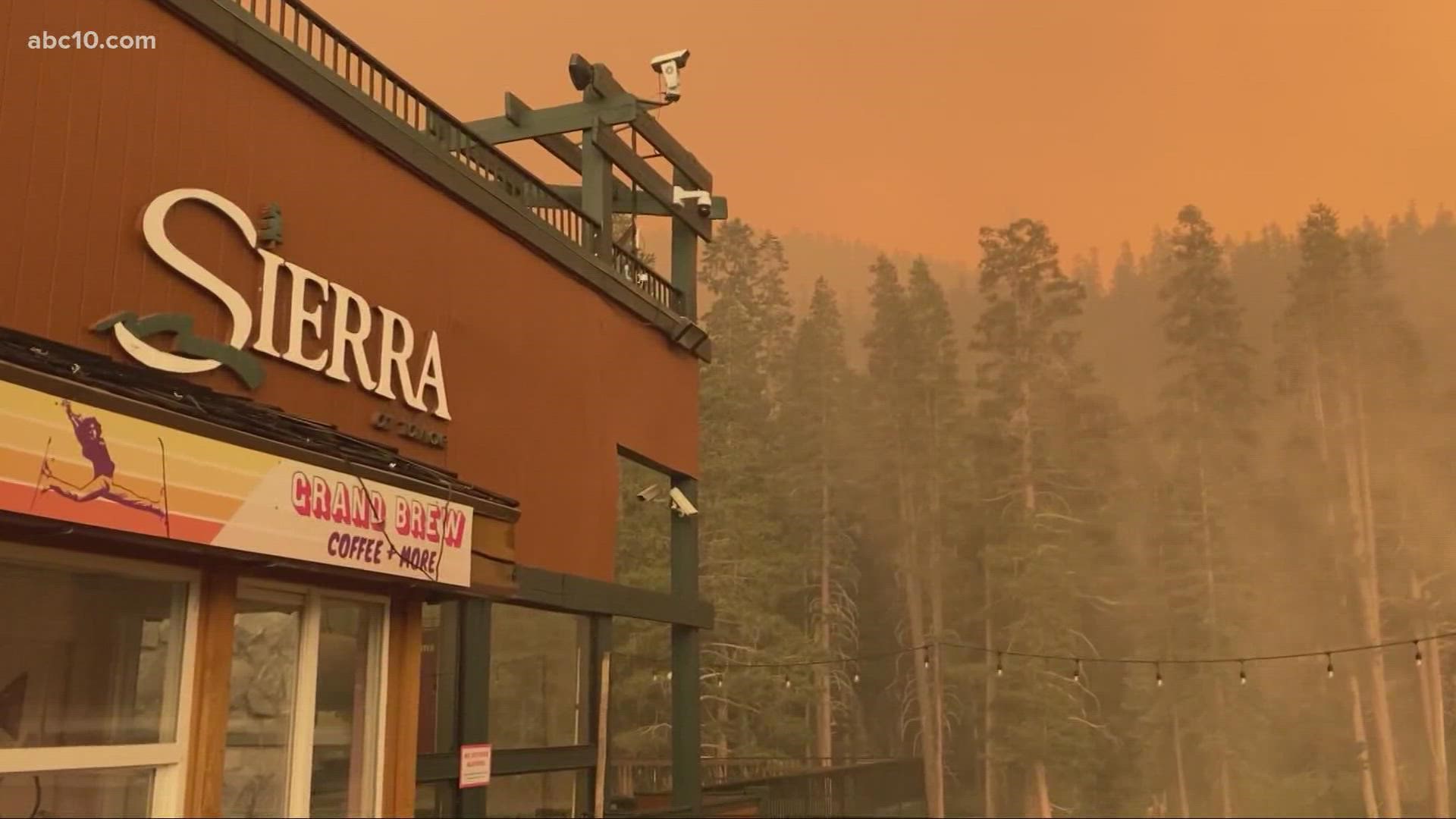
Flames began to appear on wildfire cameras near the Sierra-at-Tahoe resort just after 7 p.m. The resort is located about 10 miles as the crow flies to the southwest of the heart of the city of South Lake Tahoe. As of 7:30 p.m., no evacuation warnings or orders have been issued for the city.
In a news release, new evacuations were also ordered for the following areas:
El Dorado County
• Christmas Valley from Highway 89 west to Echo Summit
• Highway 89 due west to Watershed Ridge/Echo Summit and south to the Amador/El Dorado County line.
• The area from Luther Pass Road, north along the El Dorado/Alpine County line to Armstrong Pass. West from Armstrong Pass to Upper Apache at Meyers. West on Upper Apache to Highway 50. West on Highway 50 to Highway 89. South on Highway 89 to the El Dorado/Alpine County line. This includes all homes on both sides of Highway 89.
• The area from Upper Apache at Meyers, north along Highway 50, to Elks Club Drive. East on Elks Club Drive to Pioneer Trail, extending due south to Upper Apache at Meyers. (This includes all homes off of Oneidas, Mandan, Apache, Ottawa and Player).
• The area North on Highway 50 from Highway 89 to Saw Mill Road. West on Saw Mill Road to Angora Ridge, extending to the Echo Summit.
Alpine County
• Highway 89 South from Luther Pass Road to Pickets Junction (Highway 88)
• West on Highway 88 to Kirkwood
The wildfire burning in El Dorado County has charred about 156,515 acres and is 19% contained. At 245 square miles, the fire is larger than the city of Chicago. Due to the fire, California Highway Patrol closed Highway 88 from Dew Drop to Highway 89.
The closure comes as the blaze continues an eastward march toward Tahoe. No evacuations for South Lake Tahoe have been announced at this time, but officials are telling Tahoe residents to prepare for the worst as the forecast in the next few weeks show increasing wind speeds.
“Today’s been a rough day. There’s no bones about it,” said Jeff Marsolais, forest supervisor for Eldorado National Forest.
At the head of the fire along the northeast side, the fire perimeter moved about two and half miles with no signs of slowing down, according to Operations Section Chief Eric Schwab. To compare the movement, he said that fire perimeter had been moving half a mile for the past couple of weeks.
Along the eastern edge, Schwab said the fire got caught in the wind, with fire about a mile away from Highway 88. Crews intend to reduce fuels along the roadway as a control point.
Schwab said firefighters have placed orders for 25 strike teams of engines, 25 bulldozers, and 25 hand crewsto move into Kirkwood for structure prep.
Sunday afternoon, ABC10's Luke Cleary reported that the winds were starting to pick up around the Caldor Fire. He shared a video of the fire as seen from Highway 50 near Twin Bridges.
Cleary reported that the staging area at Sierra-at-Tahoe has moved to Echo Summit due to smoke and nearby burning fires on Highway 50. He shared video of firefighting crews staying in the area to defend against the fire.
The area has become an important junction as firefighters try to stop the fire from spreading into the east. More than 600 structures have been destroyed and at least 21,000 more were under threat.
Evacuations and Road Closures
Click HERE for in-depth evacuation orders and warnings in El Dorado County. For evacuation orders and warnings in Amador County, click HERE for the Amador County Sheriff's Facebook page and HERE for their website. For current state highway/route information visit roads.dot.ca.gov.
Evacuation centers
El Dorado County Shelters
- Green Valley Community Church, Placerville, CA
- Cameron Park CSD, Cameron Park, CA
- Rolling Hills Church, El Dorado Hills, CA
Nevada County Shelter
- Truckee Veterans Hall, 10214 High St, Truckee, CA
Nevada Shelter
- Douglas County Community Center, Gardnerville, NV
Animal Evacuation Centers:
- El Dorado County Animal Services (small animals), Diamond Springs, CA. For animal evacuation questions or assistance call (530) 621-5795
- Amador County Fairgrounds (large animal)- for Amador County residents only, Plymouth, CA
- Douglas County Animal Services (small animal), Gardnerville, NV (775) 782-9061
- East to West Coast Grooming, Gardnerville, NV (775) 450-1743
- Douglas County Animal Services (livestock) Douglas County Fairgrounds, Gardnerville, NV (775) 782-9061
Accounts to follow
Evacuation Maps
A map of evacuations from the El Dorado County Sheriff's Office is available below.
Wildfire map
Click here for a map of the Caldor Fire.
►Stay in the know! Sign up now for the Daily Blend Newsletter
What questions do you have about the latest wildfires? If you're impacted by the wildfires, what would you like to know? Text the ABC10 team at (916) 321-3310.
Wildfire Preps
If you live in a wildfire-prone zone, Cal Fire suggests creating a defensible space around your home. Defensible space is an area around a building in which vegetation and other debris are completely cleared. At least 100 feet is recommended.
The Department of Homeland Security suggests assembling an emergency kit that has important documents, N95 respirator masks, supplies to grab with you if you’re forced to leave at a moment’s notice. The agency also suggests signing up for local warning system notifications and know your community’s evacuation plans best to prepare yourself and your family in cases of wildfires.
Some counties use Nixle alerts to update residents on severe weather, wildfires, and other news. To sign up, visit www.nixle.com or text your zip code to 888777 to start receiving alerts.
PG&E customers can also subscribe to alerts via text, email, or phone call. If you're a PG&E customer, visit the Profile & Alerts section of your account to register.
WATCH ALSO: