
CALIFORNIA, USA — 7:30 p.m. update:
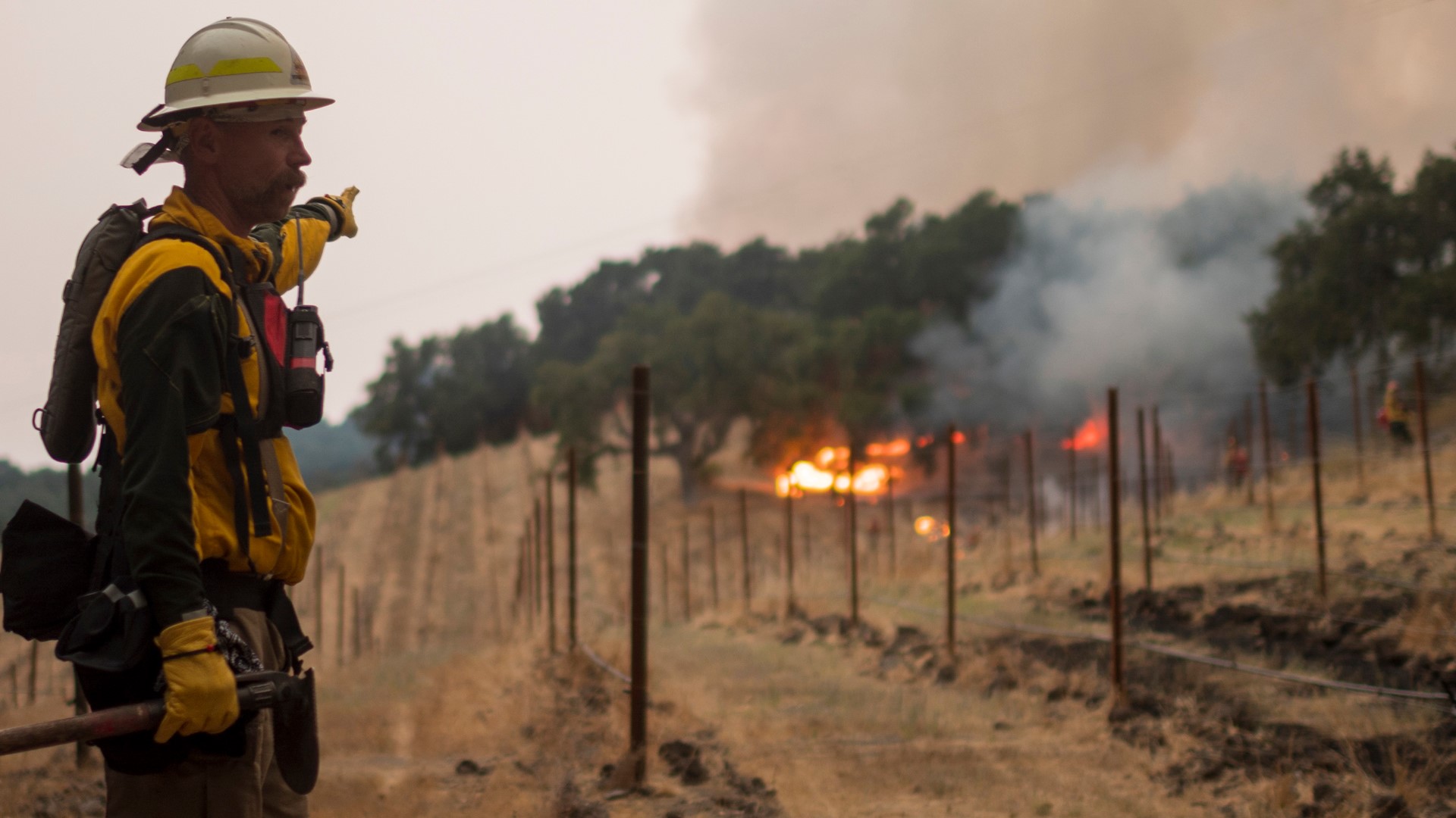
The LNU Lightning Complex Fire has grown to 351,817 acres, destroying another 37 structures since Cal Fire's Monday morning update.
The fires continue to impact multiple communities in Napa, Lake, and Sonoma County. A total of 908 structures have been destroyed with more than 30,000 still threatened.
At 294,602 acres, the Hennessey Fire in Napa and Lake Counties is the biggest of the fires that make up the LNU Lightning Complex Fire. Crews have the Hennessey Fire 29% contained.
In Sonoma County, the Wallbridge Fire burning west of Healdsburg, is at 54,503 acres and is 7% contained. Meanwhile, the Meyers Fire, north of Jenner, is at 2,360 acres and is 96% contained.
Total containment on the LNU Lightning Complex Fire is 25%.
3:30 p.m. update:
Areas in Sonoma County have downgraded to evacuation warnings, according to Cal Fire.
The area east of the Sonoma Coast, north of the Russian River, West of Myers Grade Rd. and South of Fort Ross Rd. is now an evacuation warning as well as the area east of Myers Grade Rd., north of the Russian River, west of Cazadero Highway and south of Fort Ross Rd.
Cal Fire is warning people to use Highway 1 to go back to their homes because Highway 116 is still closed east from Cazadero Highway.
2 p.m. update:
Evacuation orders were downgraded to evacuation warnings for Wooden Valley and Gordon Valley to the Napa-Solano County line as well as the Circle Oaks subdivision, according to Cal Fire.
Soda Canyon Rd. from Loma Vista to the dead end and Atlas Peak from the Bubbling Well Pet Cemetery to the Circle R Ranch are now evacuation warnings.
Highway 121 closure is now moved to the intersection at Long Horn Ridge Rd. There is still no access to Long Horn Ridge Rd.
Cal Fire says that they are working on restoring utilities, so residents could have limited or no utilities in these areas when they return.
Cal Fire is also asking people to not donate directly to them, especially food, because they do not have the infrastructure to accept donations right now.
"This is carefully regulated in fire camp by health and safety ordinances, and adheres to COVID-19 regulations," said Cal Fire in a press release.
Instead, they are asking people to contact their local Red Cross or other organizations helping out to see if they need donations or to ask for information on how they can help evacuees.
11:30 a.m. update:
Another person has died as wildfires burn across Northern California, according to Cal Fire. Five people have now died in the LNU Complex fires.
The body was discovered by crews in Solano County.
1.4 million acres have burned across California since August 15, according to the Unit Chief Shana Jones from Cal Fire.
"Everyone on the line is extremely tired but working so incredibly hard," said Jones during a Facebook Live Monday.
The LNU Complex Fires have burned 350,030 acres and are 22% contained.
"I want to remind everyone it's August," said Cal Fire Unit Chief Shana Jones. "We have a few more months of fire season. So I am asking everyone to be prepared."
Cal Fire Chief Kavanaugh says people should expect to see smoke columns rise Monday afternoon, explaining that they have been held down by inversion.
Repopulation is a priority for Cal Fire. Kavanaugh suggests when people are able to get back to their homes to do a safety check of their homes and property.
11 a.m. update:
Officials from Cal Fire Sonoma-Lake-Napa Unit provide updates on the LNU Complex Fires. The fire, which is burning across five counties, has grown to 347,630 acres. It is now the second-largest wildfire in state history, according to Cal Fire.
To watch the press conference, click play on the Facebook Live video below. If you cannot see the video, click here.
7:15 a.m. update:
The LNU Lightning Complex Fires grew slightly overnight to 350,030 acres. Cal Fire said they now have the fire 22% contained but are watching for thunderstorms expected in the area on Monday.
Cal Fire also reported a new death from the fire in its latest release on Monday morning. The new death is listed in Solano County. Five people have now died in the fire.
Original Story:
Firefighters are keeping a close watch on the weather Monday, as they try and contain the LNU Lightning Complex Fires.
The fire, which is burning across five counties, has grown to 347,630 acres. It is now the second-largest wildfire in state history, according to Cal Fire.
Containment on the fire is now up to 21% but firefighter warn of extreme fire behavior and the possibility of new fires as dry lightning and thunderstorms could cause erratic winds.
871 buildings have been destroyed in the fire, and another 234 have been damaged. There are still 30,500 buildings threatened by the fire.
Cal Fire reports more than 1,800 firefighters are working to battle the fire but adds that air resources have been stretched thin because of multiple fires burning in California.
Officials also said evacuation orders should be taken seriously and that they are given because they are "based on an immediate threat to life."
They told residents in the fire areas to listen for a siren to signal evacuations. Evacuation sirens are in all emergency vehicles and are prepared to go off when they are needed. Officials played the siren and described it as a "high-low" sound.
"If you hear the high-low, it is time to go," said an official.
Napa County evacuations
Napa County Information Line: (707) 253-4540
- Highway 128 between Monticello Dam and Moskowite Corners (SR128/121 intersection)
- Wragg Canyon
- Markley Cove
- Pleasure Cove
- Highway 121 (Monticello Rd) Between Moskowite Corners (SR128/121 intersection) and Vichy Avenue
- Moskowite Corners area
- Community of Circle Oaks
- Wooden Valley Road areas
- Highway 128 (Capell Valley Road/Sage Canyon Rd) from Silverado Trail to Hwy 121 (Monticello Road)
- Steel Canyon Road
- Community of Berryessa Highlands
- Chiles and Lower Chiles Pope Valley Roads
- Berryessa-Knoxville Road from Hwy128 (at Turtle Rock) to Lake County Line
- Community at Spanish Flat Loop Road
- Community of Berryessa Pines
- Both sides, including resorts and recreational areas of Lake Berryessa, Knoxville
- Deer Park Road from Silverado Trail, east to Howell Mountain Road
- Community of Deer Park
- St. Helena Hospital
- Howell Mountain Road, east to Pope Valley
- Community of Angwin
- Pacific Union College
- All of Pope Valley Road and connecting roads
- Pope Valley Cross
- Hardin
- Aetna Springs Road
- James Creek Road
- All of Butts Canyon Road and connecting Roads in Napa County of Napa
- Snell Valley Road
- Stagecoach Road
- Community of Berryessa Estates
- Properties on roads east of Silverado Trail North, between Rosedale Road and SR128 (Sage Canyon Rd)
- Glass Mountain Road
- Crystal Springs Road
- Lommel Road
- Dutch Henry Road
- Pickett Road
- Clover Flat Road
- Properties on the east side of Highway 29 between Silverado Trail and Lake County line
- Old Lawley Toll Road
- Palisades Road
- Atlas Peak Road from Bubbling Well Pet Cemetary at 2462
- Atlas Peak Road, east to the dead end
- Soda Canyon Road from Loma Vista Road, east to the dead end
Sonoma County evacuations
Evacuation Zone - 1D1
- East of the Sonoma Coast
- North of Hwy 116
- West of Myers Grad Road
- South of Fort Ross Road
Evacuation Zone - 1D2
- East of Myers Grade Road
- North of Russian River
- West of the Austin Creek (the actual creel)
- South of Fort Ross Road
Evacuation Zone - 1D3
- East of the Austin Creek
- North of Russian River
- West and South of Old Cazadero Road
Evacuation Zone - 1D4
- East of Old Cazadero Road
- North of Russian River
- West of Armstrong Woods Road and Sweetwater Springs Road
- South of McCray Ridge Road and Pool Ridge
Evacuation Zone - 1D5
- East of Armstrong Woods Road
- North of the Russian River
- West of Westside Road
- South of Sweetwater Springs Road
Evacuation Zone - 1B3
- East of McCray Ridge Road and Pool Ridge
- North of Old Cazadero Road
- West of King Ridge Road
- South Skaggs Springs Road
Evacuation Zone - 1F2
- All areas south of the Russian River
- East and North of Hwy. 116 (Pocket Canyon)
- West of Martinelli Rd.
Evacuation Zone - 2A3
- North of Stewarts Point Skaggs Springs Road to the eastern edge of Lake Sonoma
- Everything west of the eastern edge of Lake Sonoma to the western boundary that runs north along the ridge line from the intersection of Stewarts Point Skaggs Springs Rd @ Old Stewarts Point Skaggs Springs Road to the interception of Rockpile Road @ Cooley Ranch Road north to the Mendocino County Line. This is a very rural area with no clear defining boundaries.
Evacuation Zone - 2E1
- South of Stewarts Point Skaggs Springs Road
- North of Palmer Creek Road and Stewart Point Skaggs Springs Road
- West of McCray Road
- East of Wallace Creek Road
Evacuation Zone - 2E2:
- South of Stewarts Point Skaggs Springs Road
- North of Chemise Road
- West of the center of Dry Creek (the actual creek)
- East of Wallace Creek Road
Evacuation Zone - 2E3
- South of Chemise Road
- North of Westside Road
- East of Wallace Creek Road
- West of the Center of Dry Creek (the actual creek)
Evacuation Zone - 2E4
- South of Palmer Creek Road
- North of McCray Ridge Road and Sweetwater Springs Road
- East of the Dry Creek (the actual creek)
Evacuation Zone - 4B1
- All areas south of River Rd. from Martinelli Rd. to the intersection of River Rd at Trenton Rd.
- West of Covey Rd.
- North of Front St. / Hwy. 116
- East of Martinelli Rd.
Evacuation Zone - 4D1
- South of Pocket Canyon/Hwy 116
- East and North of Green Valley Road
- West of Atascadero Creek
Lake County Evacuations
Hidden Valley Lake / Jerusalem Valley Areas
- North of Butts Canyon
- South of Hofacker Ln. to Morgan Valley Rd.
- East of Hwy 29
- West of Lake / Napa County line
- East of Middletown Area
- East of Hwy 29
- North of Lake / Napa County line up to the intersection of Hey. 29 and St. Helena Creek (Across from Twin Pine Casino)
- St. Helena Creek Rd
- South of Butts Canyon Rd.
- Lower Lake Area (South)
- East of Hwy. 29
- South of Morgan Valley Rd.
- West of Lake / Napa County line
- North of Hofacker Ln. extending east to Morgan Valley Rd. Lower Lake Area (North)
- North of Morgan Valley Rd.
- East of Sky High Ridge Rd. extending north to Hwy. 20
- South of Hwy. 20
- West of Lake / Napa / Colusa County lines
- Middletown AreaWest of Hwy. 29
North and East of Lake / Napa
- South of Anderson Springs Rd. / Neft Rd. / Boggs Mt. Rec. Area extending northeast to Hwy. 29 / Hofacker Ln. Lower Lake Area
- East of Big Canyon Rd. / Perini Rd. / Seigler Canyon Rd.
- South and west of Hwy. 29
- North of the previous evacuation order / warning line of Anderson Springs Rd. / Neft Rd. / Boggs Mt. Rec. Area extending northeast to Hwy. 29 / Hofacker Ln.
Solano County Evacuations
Most evacuations have been lifted in Solano County, including those in the city of Vacaville, and unincorporated areas in Fairfield and Suisun.
For updated evacuation information in Solano County check the map here.
Yolo County Evacuations
Residents in Zone 1 are still under a mandatory evacuation order, all other areas have been cleared to return home.