
RED BLUFF, Calif. — Update: September 7, 2019 - 9:12 p.m.
The Red Bank Fire has reached nearly 9,000 acres as it continues burning west of Red Bluff.
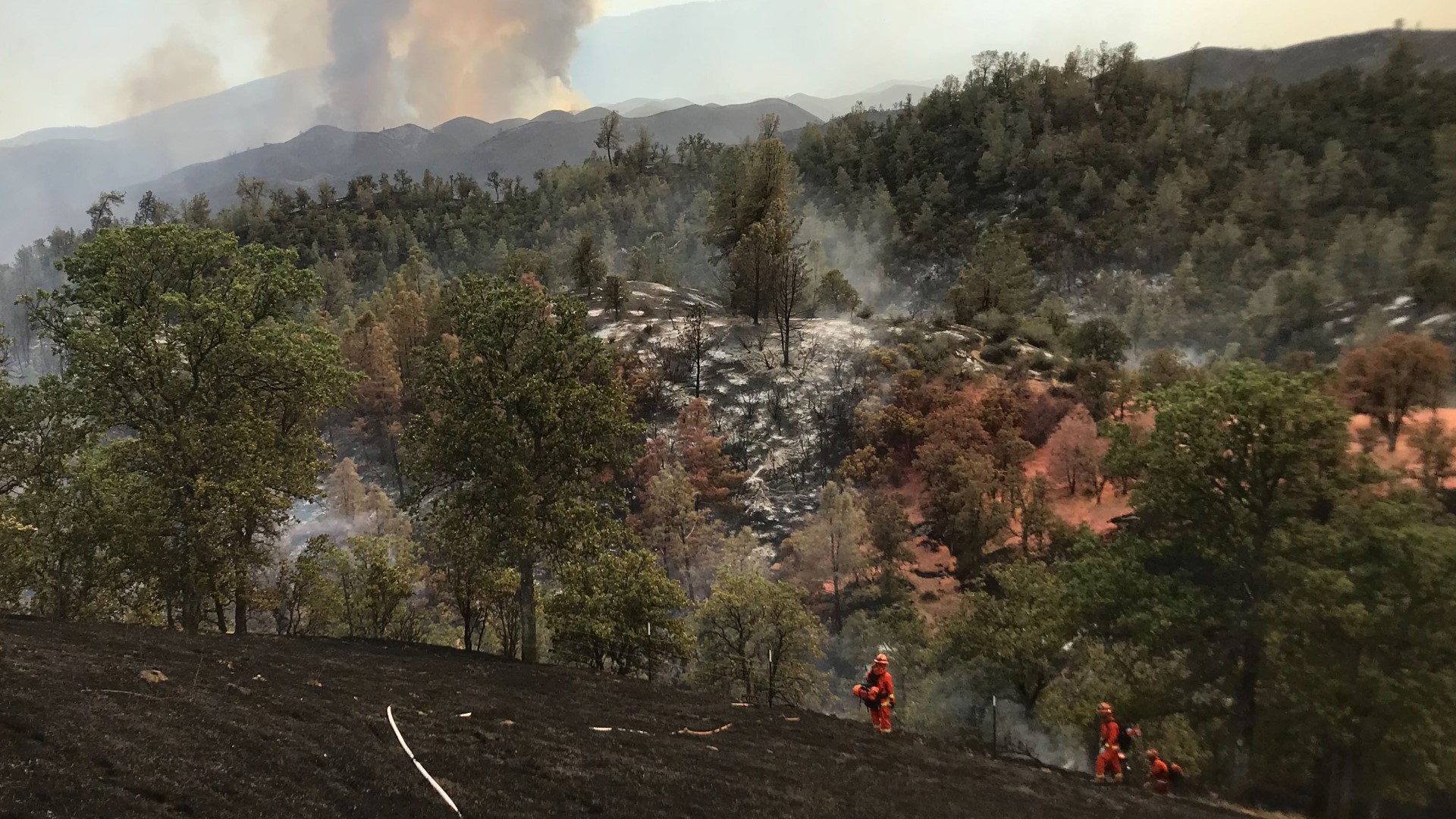
Narrow roads and poor access to the fire area remain a problem for firefighters battling the fire, but plans are being made to fly firefighters into the fire line to help with containment efforts.
With more than 1,500 fire personnel at the fire, crews have been able to secure 15% containment on the fire so far.
Mandatory evacuations are still in place for the areas south of Highway 36 between Tedoc Road and Vestal Road, and between the Shasta-Trinity National Forest boundary and the Four Corners intersection.
An evacuation warning is in effect for the greater Red Banks Community east of Joint Road located on and from Bell Road.
Update: 10:30 a.m.
The lightning-sparked Red Bank Fire is now at 7,754 acres and 9% contained, according to a Cal Fire update on Saturday morning.
The fire is burning west of the Red Bluff community in Tehama County in remote, very steep and rocky terrain.
Cal Fire said narrow roads and poor access to the fire area are challenging firefighters and they are working to fly crews in to assist with containment.
Weather has been hot and dry in the area, with poor humidity recovery overnight, according to Cal Fire. Officials expect winds to increase over the weekend and possibly make containment more difficult.
As such, fire danger remains high and people in the area are asked to use extreme caution and refrain from daily activities that may spark a wildland fire.
RELATED:
Drivers in the area are asked to slow down, yield to emergency vehicles and be aware of firefighters who may be on the roads and highways.
To prepare for an evacuation, visit “Ready, Set, Go” — a user-friendly website that shows homeowners step-by-step instructions for hardening their homes and protecting their families from the dangers of wildfires.
Mandatory Evacuations: Areas south of Highway 36 between Tedoc Road and Vestal Road, and areas between the Shasta-Trinity National Forest boundary and the Four Corners intersection.
Evacuation Warning: The greater Red Banks Community east of Joint Road located on and from Bell Road.
Update: 7:30 p.m.
A lightning-sparked wildfire continues to burn west of Red Bluff. Officials say the Red Bank Fire is burning in a remote area with steep and rocky terrain.
Cal Fire told ABC10 that this terrain is the reason why the fire is going in different directions as it burns up hills and into canyons, a stark difference from it being wind-driven on Thursday.
Firefighters are faced with narrow roads and poor access to the area. Air tankers are being used to put retardant lines around the fire in an attempt to slow it down and let the ground crews get to work.
According to Cal Fire, plans are being made to fly firefighters into the fire line to help with the containment efforts.
Mandatory evacuations are in place for areas south of Highway 36 between Tedoc Road and Vestal Road and between the Shasta-Trinity National Forest boundary and the Four Corners intersection.
The greater Red Banks Community east of Joint Road located on and from Bell Road currently stand at an evacuation warning.
Nearly 1,500 fire personnel are in the area combating the Red Bank Fire, which has already burned 7,340 acres. It stands at 7% containment.
Update: 6 p.m.
The lightning-sparked Red Bank Fire near Red Bluff continues to burn at 7,340 acres with 7% containment.
At this time, there are no reported injuries, and no buildings have burned, though some building are being threatened.
Mandatory evacuations remain in place for Pettyjohn Road to the Forest Service Boundary. Road closures have also been put in place.
While the Red Bank Fire was driven by strong winds on Thursday, Cal Fire says the terrain is what's making the fire burn in different directions as it runs up hill and burns through canyons on Friday.
Air tankers, some with more than 9,400 gallons of fire retardant, are being used by putting retardant lines around the fire to slow it down and let the ground crews do their work.
Original story:
In Northern California, a lightning-sparked fire in a remote area of Tehama County west of the city of Red Bluff dubbed the Red Bank Fire has grown to 6,500 acres and 5% contained.
Evacuations have been ordered for rural properties. According to Cal Fire, the fire is difficult to get to because of its remote access. No structures have been destroyed or damaged, yet.
Mandatory Evacuations for are in place for Pettyjohn Road to Forest Service Boundary and for Red Bank Oaks Subdivision, and R-Wild Horse Ranch.
ABC10 meteorologist Rob Carlmark suggests smoke from the Red Bank Fire, paired with Saturday winds, could be an issue.
RELATED:
Firefighters have made progress against a wildfire that burned dangerously close to homes in Southern California while another blaze has exploded in size in a remote area at the northern end of the state.
An approximately 3-square-mile threatening the communities of Murrieta and La Cresta is 20% contained early Friday.
Some roads have reopened but mandatory evacuation orders for about 570 homes remain in place, along with a voluntary evacuation advisory for another 2,200.
The Tenaja Fire broke out Wednesday, possibly from a lightning strike as thunderstorms moved through.