SACRAMENTO, Calif. — Monsoonal moisture moving up from the south will bring the potential for thunderstorms with abundant lightning and little rainfall across portions of interior northern California Sunday through Monday.
Thunderstorms may develop Sunday afternoon over the Sierra south of I-80, then spread northward into portions of the Coastal Range, the southern Cascades and the northern Sierra north of I-80 overnight.
Isolated thunderstorms may also develop in the Central Valley. The best thunderstorm potential will be over the mountains. Given critically dry fuels, any lightning strikes may result in a high probability of ignition. This possibility for abundant lightning on dry fuels could generate new fires.
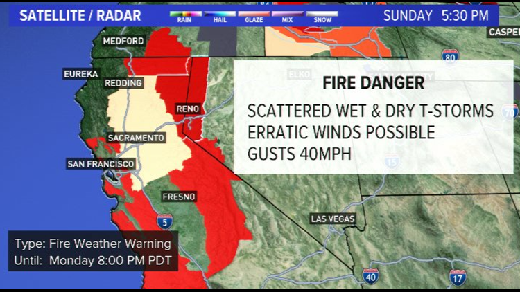
For that reason, the National Weather Service has upgraded the Fire Weather Watch to a red flag warning for the Northern sierra front, Tahoe Basin and Northeast California from midnight Sunday night to 8 pm Monday for abundant lightning on dry fuels.
Isolated to scattered mixed wet and dry thunderstorms late Sunday night through Monday. These storms could produce outflow winds with gusts up to 40 mph possible. These winds could spread fires quickly and may change direction quickly due to erratic wind gusts.
Impacts...Recent hot and dry conditions have created very receptive vegetation to new lightning fires. New fire starts may combine with outflow winds to cause a fire to rapidly grow in size and intensity before first responders can contain them.
Avoid outdoor activities that can cause a spark near dry vegetation, such as yard work, target shooting, or campfires.
----------------------
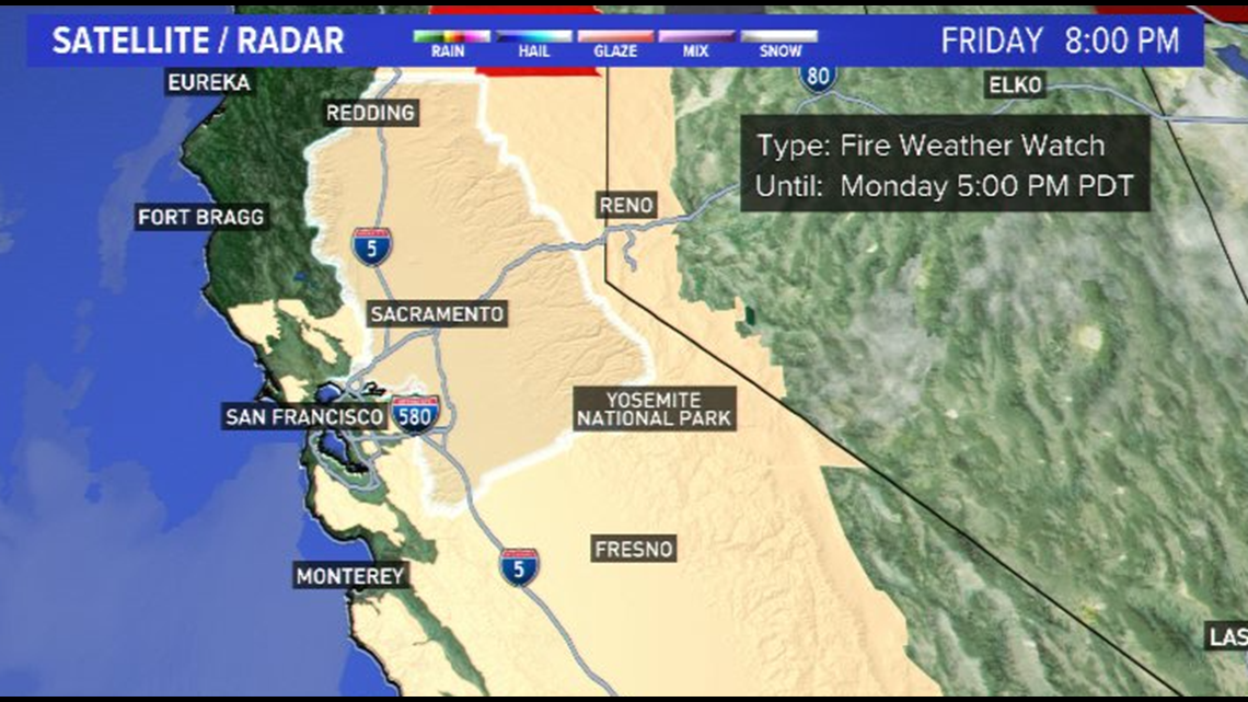
There is a Fire Weather Watch advisory issued by the National Weather Service for Sunday afternoon through Monday afternoon for dry thunderstorms.
Thunderstorms with little rainfall are forecasted to happen late Sunday through Monday producing dry lightning which could lead to new fires. Monsoonal moisture moving up from the south will bring the potential for thunderstorms with little rainfall across portions of interior northern California late Sunday through Monday.
Thunderstorms may develop Sunday afternoon over the Sierra south of I-80, then spread northward into portions of the Coastal Range, southern Cascades, and the northern Sierra north of I-80 overnight. Isolated thunderstorms may also develop in the Valley.
The best thunderstorm potential will be over the mountains. Given critically dry fuels, any lightning strikes may result in a high probability of ignition.

The potential for fire starts with any lightning. The rapid spread of fire is possible depending on terrain and local wind conditions.