SACRAMENTO, Calif —
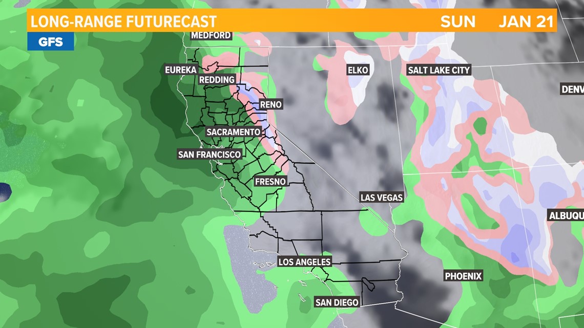
The most significant rain event of the wet season is on the way to Northern California. A series of weak atmospheric rivers will pump moisture into the state, bringing periods of heavy rain and high elevation snow.
Beginning Friday evening, rain will be possible every day through Wednesday, January 24.
The stormy pattern this weekend is thanks to the Pacific jet stream extending across the Pacific all the way from Japan. The jet stream will draw in warm, moist air from the tropics and temperatures will remain elevated through the extended forecast thanks to the influx of mild Pacific air.

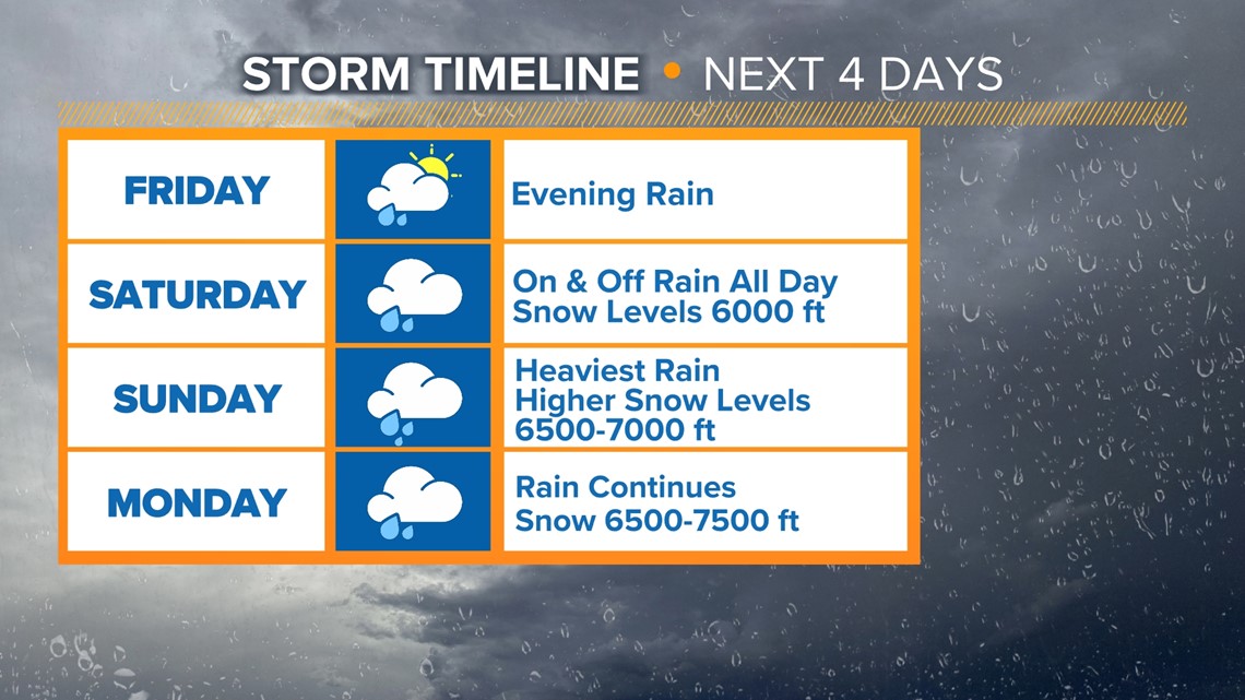
As a result, snow levels will be elevated. Beginning Friday, as the first bands of rain push onshore, snow levels will hover between 6,000-7,000 feet through Monday. In comparison, the colder systems the last couple of weeks saw snow levels drop below 2,000 feet at times.


Rain isn’t expected in the valley until late Friday night. Expect showers to begin after 8 p.m. with showers moving west to east. The first wave of rain will produce showers through the overnight hours and the valley is expected to receive around 0.25-0.50" through Saturday morning.
Saturday will see lighter rain and it will be showery in nature. Rain will be possible in Santa Clara for the NFC Divisional matchup between the 49ers and the Packers at 5:15 p.m.
The heaviest precipitation will be Sunday night and into Monday. Snowfall rates during this period will be heavy and travel is not advised.

A Flood Watch is in effect for the Sacramento Valley and Sierra foothills from Sunday afternoon to early Tuesday morning. Some water is expected to flow through the Colusa and Tisdale weirs along the Sacramento, though flooding of major rivers like the Sacramento, American, San Joaquin, Tuolumne, Cosumnes, Yuba and Merced is NOT expected. Most of these rivers will stay well below even the monitor levels. However, local creeks and streams will be running very high and some localized flooding is possible.


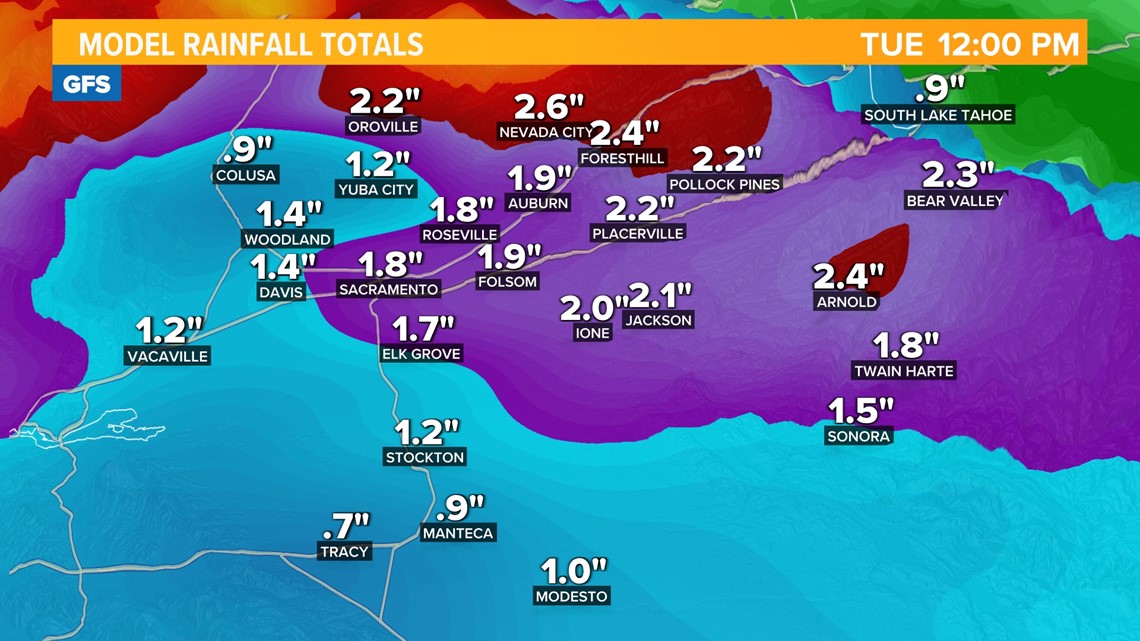
Rain totals will be impressive from this system with the valley expected to pick up 1-3" through Monday with the highest totals being north towards Redding. Heavy rain is expected in the foothills and Sierra (below 6,000 feet) with 2-6" expected.

Snow totals between 6,000-7,000 feet will range from 8 to 16 inches and 1 to 2 feet is possible above 7,000 feet by Monday night. Areas below the passes will pick up a few inches then see it melt due to rain from the second storm, then potentially get a little bit more right at the tail end, so it'll be tough to stick a ruler in the ground because rainfall from the second storm will likely melt some of the accumulation from the first storm.
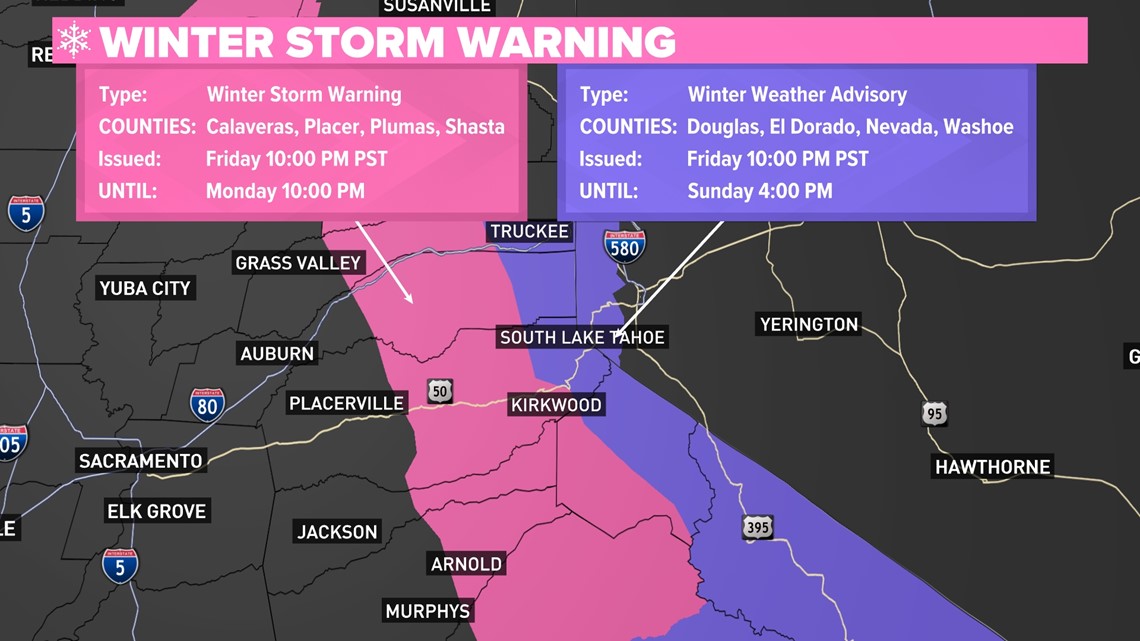
A Winter Storm Warning is in effect from Friday night through Monday night in the Sierra.

Following the active week ahead, the Climate Prediction Center favors drier and warmer conditions over the 8-14 day period with high pressure becoming the dominant weather feature for the state.
WATCH ALSO: How did Lake Tahoe gets it name?