
Water Wasted | What happened to California's water from the historic winter?
The state had a historic winter and the ABC10 Weather Team is investigating where the water is going and if we're wasting it

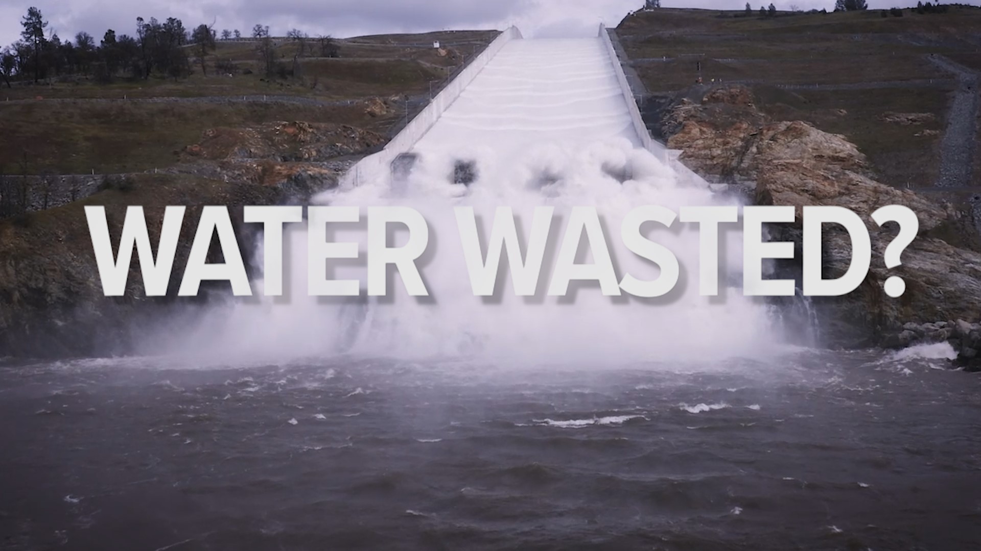
Is California wasting its water? The state had a historic winter and the ABC10 Weather Team is investigating where the water is going and if we're wasting it. Here are all four parts of our investigation.
Chapter 1 How does California measure its water supply?
There’s an old saying in mountain towns that there’s nothing better than the first snow of the season and nothing more unwelcome than the last snow of the 2022-23 season.
Like a distant relative coming to visit, this past winter showed up early and stayed late, but family is family. Similarly, the love runs deep for Jason Rolfe in South Lake Tahoe.
He grew up in the area, left for work and school, and couldn’t wait to come back to play in the snow knowing it’s ground zero for the water the state needs to function.
“We do appreciate that we are the ones holding the snow for the rest of California. You know, the rivers, the fishing, the lakes, helping with the drought. It really does roll downhill and it helps everybody else out. We're happy to be the stewards of the snow until you're ready for it,” Rolfe said.
He wanted to document the moment the snowpack turns to snowmelt. As it seemingly breathes, it is in fact bringing life to plants, animals and people hundreds of miles down the hill.
"These manual measurements are just as important as all the other measurement methods that we have,” said Sean de Guzman with the Department of Water Resources.
He might wield the single most powerful pole in California. He helps make manual measurements of the snowpack to help nail down how much water the state will have once the snow melts.
De Guzman measures the depth of the snow and how much water is in the snow to have an idea of the yearly water supply. This tried-and-true method backs up the hundreds of automated sites in the state.

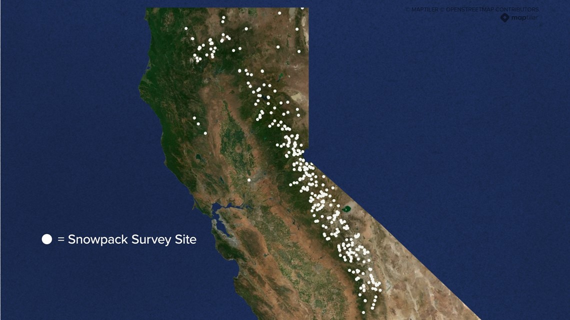
“This is the only in-person boots-on-the-ground field verification, where we can actually verify that the automated sensors are great, but they are out in the backcountry exposed to wilderness, exposed to all the elements, exposed to bears, everything you can imagine," he said.
As crucial as the measurement is, you need more to precisely identify such an important metric. After all, the snowpack delivers a third of the water the state will need for the dry summer months.
"As time has gone on from the 1920s when our population was quite small and the agricultural demands on water were small, and then the environmental demands on water were also small, right? All of that, we've gone from that all the way to this time, where our population is enormous and we have all of these demands to where we're down really to each waterdrop. That matters,” said Tom Painter.
What started as a jet propulsion laboratory experiment with NASA has turned into a foundation of the future. Airborne snow observatories use laser and spectrometer measurements of the snowpack from the sky.
“Now, with our quantity of measurements and those accurate measurements, they can know to within about 2% how much water they're going to get as a minimum,” said Painter.
Almost every basin and range in the West is using these modern techniques to measure the snowpack because it will only become more important to get the data right as winters become more unpredictable in the Golden State.
“It could be a banner year one year and it could be drought the next. You just never know living up in the mountains,” said Rolfe.
Chapter 2 How does California store its water supply?
Reservoirs are the first line of water storage in California. There are around 1,500 yet there's still a need for more water most years.
"We built our water system in California principally around scarcity and that is because two out of three years, we don't have enough water," said Jeffrey Mount with the Public Policy Institute of California.
To address that scarcity, California built one of the most elaborate water conveyance systems in the world; capturing snowmelt runoff, storing it above and below ground, then moving it vast distances. Without it, California wouldn’t be the economic powerhouse it is today.
But that system is being pushed to meet multiple needs from water storage to flood control plus recreation, hydropower and the environment.
"We ask a lot of these reservoirs, but our reservoirs are principally built as water supply structures, and that's the way we operate them. Except in the winter, right? I mean, this is one of the things that everybody forgets that in the winter, let's take this wet year that we're having in 2023, we're going to end up with more water than we know what to do with in the fall. And I know what we're going to do is we're going to have to let that water go so we make room for potential floods next winter," said Mount.
It creates tension between flood managers and people wanting to see a full reservoir for water supply.
"So much of how that's operated is based on manuals and calendars that were put into place 30, 40, 50 years ago. Things change," said Daniel Bays.
He's a third-generation farmer in the Central Valley. He, like many other farmers, relies on water coming from Northern California.
"If you look back, we have cycles. We have wet cycles and dry cycles in the state and that's what a lot of the reservoirs and canal systems were built for was to help manage that," said Bays.
With a growing population, the water supply structures are starting to get stretched close to their breaking point.
Drew Lessard with the U.S. Bureau of Reclamation that runs Folsom Dam says the concern is guiding managers to rethink reservoir operations.
"Where do we get to that point where we can ask no more of it? Probably we're getting close to that but we're still looking at ways that we can make and gain efficiency," he said.
Lessard says part of making Folsom more efficient will be expanding its capacity.
"Well, the Corps has a project right now and they already started a year or so ago on raise. The Corps has authorization to raise Folsom Dam three feet," said Lessard.
It'll make room for even more storage. Another project in the works is updating operation manuals. They will rely on improving forecasts, giving reservoir managers more certainty about how much water to let out and how much they can keep in.
"It's sort of the software. The hardware has been built, and now it's how do we work the software on how we route things," said Lessard.
With so many uses, Folsom is sometimes called "the little dam that could." Even beyond flood control and water supply, it's also the first responder when it comes to sending water south towards the Sacramento-San Joaquin Delta to help keep the water fresh and not salty.

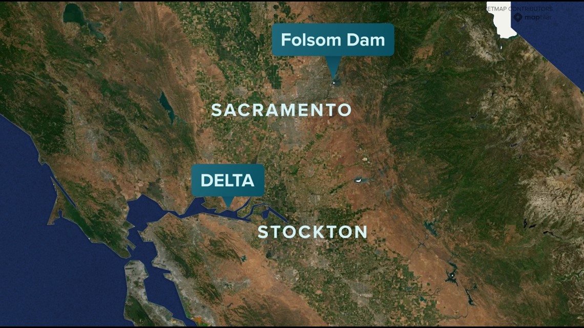
This is quite possibly one of the biggest bones of contention for “water wasted to sea.”
"That seems to be the bigger issue that I see as usually, environmental groups aren't that eager to work with farmers or look at growers that are south of the Delta as big evil corporations. It's sad," said Bays.
He says farmers are constantly put into a corner and blamed for wasting water. He says there are still solutions out there.
"Everyone talks about getting another reservoir and I think a reservoir in the right place would be a good tool for us to use," he said.
An American River Basin study found an upstream, additional reservoir may help to address the climate whiplash with more rain than snow falling in the Sierra. One project being considered is the Alder Reservoir.

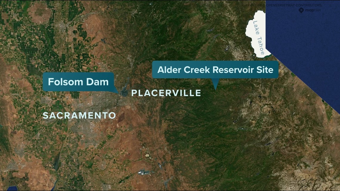
"It's strategically located so that when there's large rain events, we could be capturing that water directly. Or as the snow melts, we're also able to capture it too and relieve some of that operational pressure on Folsom," said Rebecca Guo with the El Dorado Water Agency.
It would help with water supply, reduce flood risk and provide cold water releases for certain fish species.
"The main benefit of it as we saw this past winter, Folsom was releasing water because there's just not enough storage capacity in Folsom, so this would be able to allow this water to be captured versus spilled where it wouldn't be able to be usable," said Guo.
The idea for the reservoir has been in the books since 1916 when a lot of agricultural growth was happening in El Dorado County. People needing water went looking upstream.
"This would be a part of a system of reservoirs along the South Fork of the American River. You know, the bottom part would be Folsom Reservoir and as you go upstream, there were up to 16 reservoirs planned at that time," said Ken Payne with the El Dorado Water Agency.
Alder Reservoir is the only one still being considered due to its location with a deep canyon perfect for storing cold water which would also help reduce evaporation loss.
"The system that we have in place really sort of began in the Gold Rush and is where we are today ... the conveyance systems that move water vast distances, water rights systems and environmental laws. I would not just say, 'Let's blow all that up,'" said Mount.
"Things change. Our demands change. Our desires as a state change and what we need changes. Crops change," said Bays.
Chapter 3 What is California doing to help increase groundwater storage?
It's been a struggle farming with no water. Daniel Bays, like thousands of other farmers, has had to deal with drought.
"I would say the stress is probably the hardest part. Part of it being in the office looking at the numbers, part of it just being out in the field with our employees and the other people that depend on this for a job, but a lot of them enjoy what they do and take some pride and ownership in growing a crop and feeding the world," said Bays.
The situation of drought isn't new. In fact, the Central Valley Project began in 1933 during the Dust Bowl to deliver water from Northern California to the valley by way of canals.
As decades go on, the seriousness of drought has increased, leaving farmers to look for alternative ways to save water.
About 400 miles of California's valley is home to more than 500 underground water basins and communities are hit hard when there's not enough water underground.
“We’ve drilled new wells to replace old wells and find more water," said Bays.
But overpumping in California has led to big problems and has never been regulated until recently.
"If more groundwater is pumped than is replenished, there could be something that's called subsidence where the land aqua surface will actually sink, and so there are areas in California that has occurred," said Steven Springhorn with the Department of Water Resources.
Once the ground sinks, there's no going back to fill it up.
In 2014, the Sustainable Groundwater Management Act (SGMA) was formed, giving local water agencies about 10 years to make plans and find solutions to conserving water.
“They have to develop long-term plans or how they're going to look at the numbers. First of all, what's the nature of their problem? Are they in overdraft? Or are they in balance? If they're not in balance? What's their solution," said Ellen Hanak.
She works with farmers and water managers in the San Joaquin Valley to assess the extent of the water problem.
"What we find is that, in a worst-case scenario, agriculture in the San Joaquin Valley could be losing about 20% of the water that it now uses for irrigation in a typical year. That's a really important input for agriculture," said Hanak.
Since SGMA, many are calling out the state for their lack of effort, especially in the most recent dry stretch.
"It's a failure of leadership. The Democratic supermajority and the governor have failed to make investments in water infrastructure and what's more, we passed a bond 10 years ago, almost 10 years ago now in 2014. Not one piece of infrastructure has been built yet," said Assemblyman James Gallagher (R-Yuba City).
Although no major reservoirs or infrastructures have been built, the state says they've been working on awarding millions in grant money for drought projects and resiliency. The Woodland-Davis Clean Water Agency is one example.
"The city of Woodland had originally been on groundwater for about 100 years. We switched to Sacramento River surface water in June 2016 and as part of that project the city embarked on an aquifer storage and recovery program," said Tim Busch with the agency.
Woodland-Davis has been ahead of its time in starting ASR wells. They used low-interest loans from the state water resources control board and more recently applied for a state grant for a fourth water well.
"The aquifer storage and recovery program is a really good way to kind of balance winter supply with summer demand," said Busch.
Also known as ASR wells, the system of pumps and pipes funnel water from a clean water source like the Sacramento River. A small amount of chlorine is added and then the water is stored underground.
"We started injecting water for the first time in 2018, so we're now in our fifth year of water injection. [The] combined capacity of the wells is about 4.5 million gallons per day injecting water into the aquifer," said Busch.
With the abundance of winter rain and flowing rivers, they stored more than 450 million gallons of water by the end of March.
"The aquifer layer that we are using is 500 feet down, 50-foot thick layer. At every wall site we have in the city, both native drawn water walls and even farmer walls outside of us... that layer exists kind of everywhere around here," said Busch.
The big question is if there's that much aquifer storage, why isn't the state doing more to store excess water underground? The answer is fairly technical but with more research scientists are beginning to see a clearer picture.
"AEM is the airborne electromagnetic surveys that we're conducting across California. Think of it as MRI for the subsurface, so it's a way that a helicopter carries a large hoop about 100 feet off the ground and it flies about 60 mph. Along certain lines are transects and it sends electrical information into the ground, which bounces off different layers below the ground surface," said Springhorn.
The technology is finding where sands and gravels are in comparison to clays and silts. Water is easily able to seep deep underground where sand lies, but a buffer is created with clay.
Springhorn says finding the clay and sand layers is critical to knowing where the state can keep groundwater.
There's even more help on the way, too. NASA's Jet Propulsion Laboratory says it's been working on a mission to help assess soils and topography underground.
"What we really get from satellite information is the ability to see the big picture. So contextually, we can kind of tie the whole story together and we can say it's not just this farm, or this that's changing... it's the entire southern portion of the Central Valley," said scientist JT Reager.
Reager works with the joint operation between NASA and India on synthetic aperture radar (NISAR). The mission will launch a satellite into orbit next year, feeding back data on the Earth's crust, depths, ice sheets and ecosystems.
"For vegetation and ecosystems, NISAR should be able to monitor changes in fragile ecosystems around the planet and how they might be changing due to various stresses, like human development and population growth," said Reager.
Stanford geophysicist Rosemary Knight has spent 30 years working on groundwater management in California.
"I think there's a real opportunity here to help the water agencies now work with this data and see how this data can help them improve and inform their planning," said Knight.
Knight and her colleagues out of UC Davis are working alongside the Department of Water Resources. What they've found is something out of the Ice Age.
"They drew an area on a map and said, 'One of these incised valley-filled deposits, one of these ends of the last glacial period Paleo valleys has to be here.' We took the airborne EM system and flew back and forth to see if we could find it with the airborne EM system, and we could. It was right there in the data," she said.
The old Paleo rivers were formed when glaciers during the last glacial period started melting quickly. Moving at a high rate of speed, the water carved pathways from the mountains to the valley moving large amounts of rock and granite material.
"It's like a fast path where if we can connect with it at one location, we can actually move water down deeper within the groundwater system of the valley," said Knight.
"We're going to be expecting more intense droughts, more intense floods and a quicker transition from one to the next," said Springhorn. "So this managed groundwater recharge is really important."
While progress for storing the excess water may be held up through water rights, ecosystem concerns and legislation, Hanak says the time to act is now.
"Our goal is really to try to bring the best information and analysis to the public, to decision-makers. That — in this case — includes growers and local water managers, local communities, and folks in the valley that are really going to be on the front lines of addressing these challenges," said Hanak.
As for third-generation farmer Daniel Bays? His hope is his kids may have the option to continue farming in California.
"My hope would be that if this is where they want to live and they want to continue farming that's an option for them. That it's feasible and there's a long lifetime ahead of them where they can do that and pass that on to the next generation if that pleases them," he said.
Chapter 4 The history of the Delta water tunnel project
A battle remains underway in the Sacramento-San Joaquin Valley Delta.
For decades, Delta residents and the state have been unable to agree on a plan to transport water from the rainy but rural northern part of the state down to the heavily populated, dry southern half.
The current Delta Conveyance Project wants to put a tunnel underneath the Delta to transport water. Former Governor Jerry Brown proposed two tunnels and Gov. Gavin Newsom narrowed it down to one.
To understand its significance and the controversy surrounding it, you need to look at the Delta.
“We have 700 miles of waterways across this, the five-county area of that we call the Delta. That's a trip down to Los Angeles and back basically in this one area,” said Jay Ziegler, Delta Watermaster with the State Water Resources Control Board. “This is the source of water for the state and federal water projects, also the Bay Area, and all the communities in the Delta and all the farms that exist across 700,000 acres.”
Water from across Northern California from the Sacramento River to Sierra snowmelt to the San Joaquin River flows into the Delta on its way out to the San Francisco Bay and the Pacific.


The Delta is home to numerous species found nowhere else. It’s an important stopover on the Pacific Flyway and it’s also a fertile agricultural region.
“About 75% of the land and the Delta is used for agriculture. Every crop from tomatoes to grapes, to potatoes and corn, rice and everything in between,” said Ziegler.
Yet the Delta is an extremely fragile place.
“I would make the argument that this area is more threatened by climate change than any other place in the United States because it's dealing with sea level rise coming from the west, and more unpredictable freshwater conditions as a result of changing precipitation,” he said.
This poses a problem for all of California and the people who depend on our food.
Right now, water transported from the Delta happens via pumping into the California Aqueduct, which runs roughly parallel to Interstate 5. The current system was built in the mid-1900s to handle a population and climate that no longer exists today.
“It was designed to manage a different type of precipitation. We don't know exactly what will happen with climate change, but it's pretty clear that we're going to have more rain falling in the winter, as opposed to snow that will then melt in the spring. The reservoirs are really designed for that spring runoff,” said Carrie Buckman with the Department of Water Resources.
The state’s plan, under the direction of the Department of Water Resources, to address these issues and future-proof California’s water is to build a tunnel underneath the Delta.
“If we had been able to have the Delta Conveyance Project online in January, we would have captured another 228,000-acre feet of water. That's enough to feed about 2.3 million people or about 800,000 households,” said Buckman.
Restore The Delta has been an outspoken critic of the project from the start.
“It’s really sad. Restore The Delta was really earnest when it went and participated with the Design Construction Authority for two years. We didn't like the project, but we figured, okay, we're going to sit at a table for two years, we're going to explain our water quality concerns around harmful algal blooms, salinity, we're going to explain our concerns around air pollution during construction. Those were the big pieces for us and they weren't addressed,” said Barbara Barrigan-Parrilla.
Graham Bradner works with the Delta Conveyance Design and Construction Authority (DCA).
The DCA is a pseudo-state office, funded and run by the 18 public water agencies that would directly benefit from the construction of a tunnel. The key players within the DCA are the Santa Clara Valley Water District and the Metropolitan Water District of Southern California.


“We did, from right from the beginning of our conceptual design process, engage local communities through a stakeholder engagement committee,” said Bradner. “Our mission with that committee was to look for ways to reduce effects, construction, designing construction effects to communities and environment within the Delta.
“They hired a contractor who did some analysis of the project as they see it, but we went through the scoping meetings where you couldn't give proper community impact, you could give your reports to a recorder. So sure, they held X amount of meetings, but if they don't listen, if they don't answer your questions and they never take your concerns seriously, is that really meaningful engagement? We don't think so,” said Barrigan-Parrilla.
When asked if the Delta communities that the DCA has engaged with have been supportive, Bradner admitted they have not been.
“None of the folks who participated in the Stakeholder Engagement Committee are really supportive of the project. That wasn't the objective. The objective was to give everyone in the community an opportunity to be part of the concept design phase,” said Bradner.
“There's a perception — I think — that if we build this, the intake will be turned on and water would flow through it all the time. And that's not the proposal. The proposal is that it would only operate at times as the Sacramento River is higher, or at times that there aren't fish present during the summer,” said Buckman.
The California State Auditor released a report in May 2023 that said the Department of Water Resources has “made only limited progress in accounting for the effects of climate change in its forecasts of the water supply and in its planning for the operation of the State Water Project.”
It goes on to say that until DWR makes more progress and uses better data, “DWR will be less prepared than it could be to effectively manage the State’s water resources in the face of more extreme climate conditions.”
“The state auditor's report says it all. It validated everything that was in our comments regarding the Delta tunnel project,” said Barrigan-Parrilla.
The timeline for a complete and functioning Delta tunnel — should it be built — is at the very earliest a decade away. Will it still be relevant by then?
“I would say the world is watching us here that if we fail to meet these challenges of balancing the needs for nature, the needs for people south of the Delta and the needs for people in the Delta, we will fail in a way that sends a despairing message to all Californians and those well beyond,” said Ziegler.


