
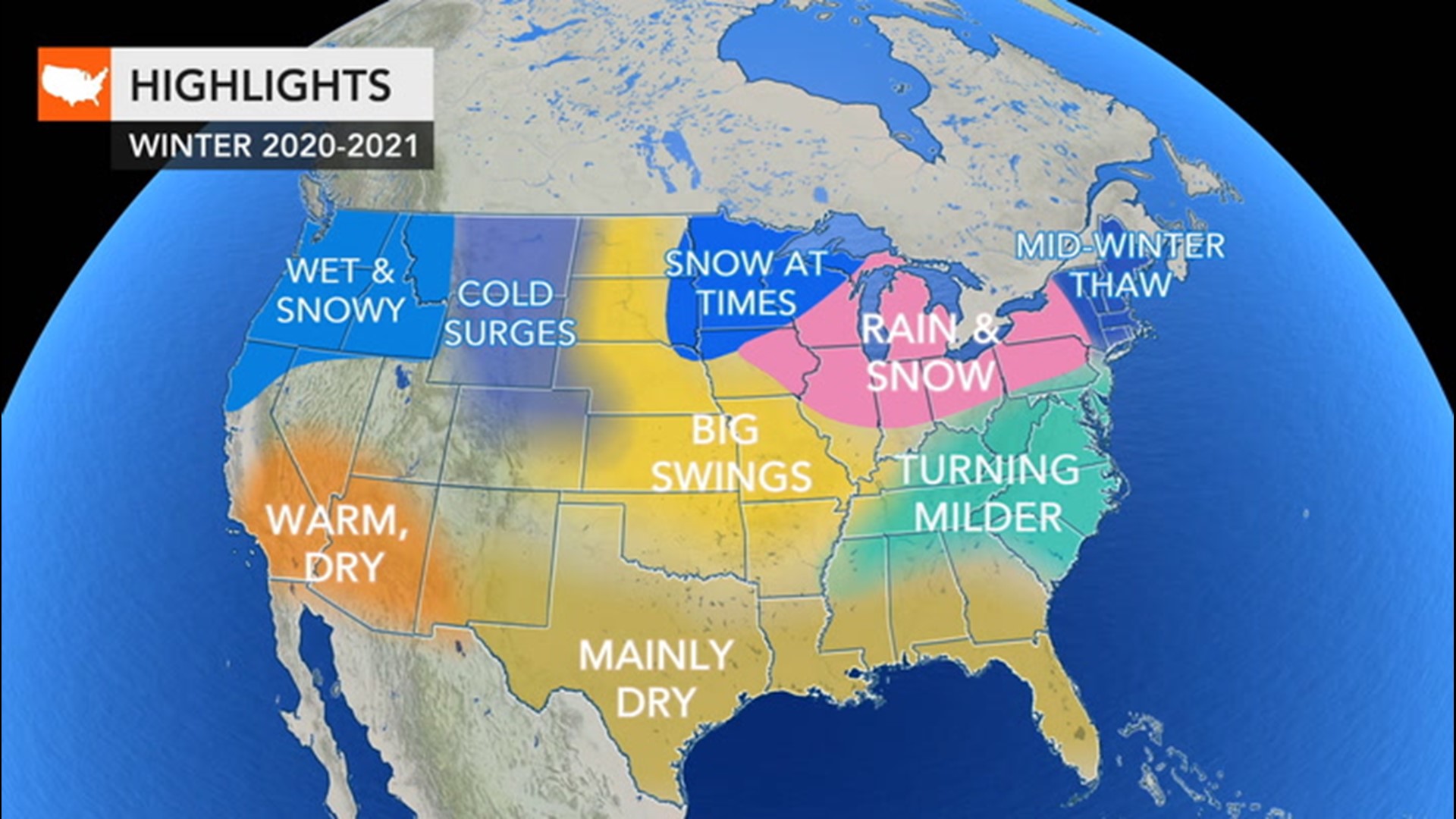
As many prepare to celebrate Hanukkah, the Festival of Lights, stormy and even snowy weather conditions are in store for parts of the United States. Weather disruptions are possible across a couple of zones of the United States as some prepare to travel or partake in small family gatherings amid COVID-19 restrictions.
Hanukkah 2020 begins at sunset Thursday evening, Dec. 10, and continues until sunset Dec. 18. Over the eight nights and eight days of the holiday, no doubt weather conditions will change from one part of the holiday to the next at most locations.
Read below for an outlook on weather conditions across the country on Thursday evening and through the weekend.
As Hanukkah begins, the majority of unsettled weather will focus on the Northwestern and part of the South Central states on Thursday evening.
A series of storms is forecast to affect the Northwest during much of the rest of December. During Thursday evening, drenching rain is expected along the coasts of Washington and Oregon with snow predicted to fall over the Cascades and farther to the east across the interior of the two states.

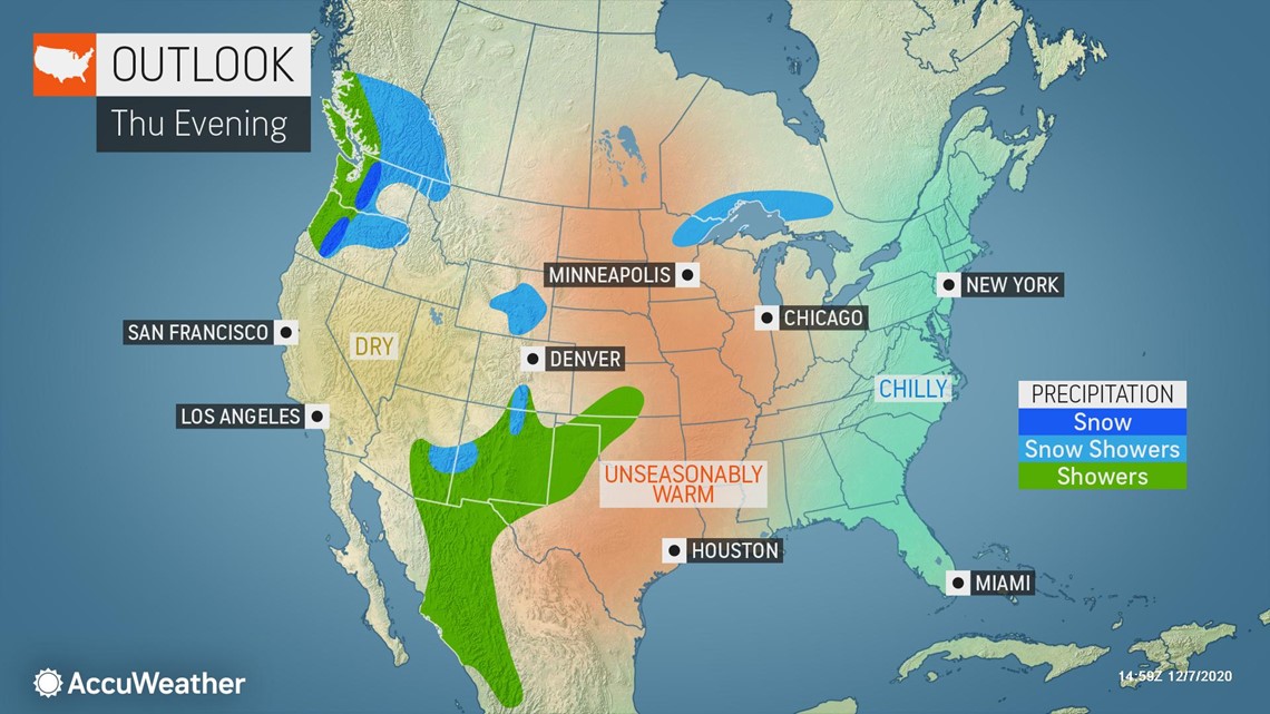
Travel through the major passes, including Snoqualmie along Interstate 90, could become slow and slippery. There is a chance that spotty snow will reach as far inland as Spokane, Washington, and rain and snow showers could dampen the Columbia River Valley along I-84.
Farther east, another storm will be brewing across the Southwestern and Central states. The storm, which is forecast to affect the Midwest as a snowstorm at the end of this week and weekend, is expected to unleash rain in portions of New Mexico, eastern Arizona, northwestern Texas, Kansas and western Oklahoma during Thursday evening. At that time, snow is likely to be limited to the mountains in southern Colorado, northern New Mexico and along the borders of New Mexico and Arizona.
"Farther to the east during Thursday evening, conditions for the middle of December will vary from rather warm over the Plains and much of the Mississippi Valley to on the chilly side from the Appalachians to the Atlantic coast," AccuWeather Meteorologist Nicole LoBiondo said.
Temperatures in both Chicago and New York City will start Thursday evening near 50 F, but temperatures may hover in the 40s much of the evening in Chicago, while a quick drop into the upper 30s is likely in New York City. However, despite the quick temperature drop in the eastern part of the nation, the overall weather pattern will trend milder into the weekend, compared to the cold start to the week.
The exact details on timing and track of the budding storm over the South Central states will unfold in the coming days.
"At the very least, that storm system is expected to bring accumulating snow to parts of the northern Plains and the northern tier of the Great Lakes and might even spread a small amount of snow and slippery travel hundreds of miles farther to the south and east over portions of the Great Lakes and Ohio Valley regions as the weekend progresses," AccuWeather Meteorologist Courtney Travis said.

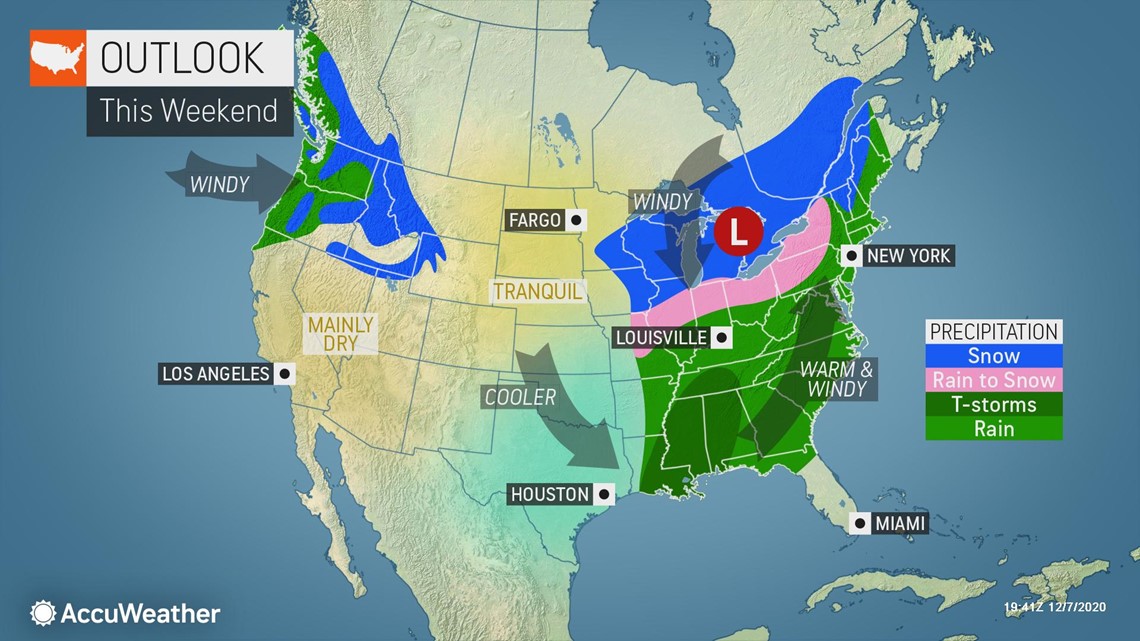
The same storm will bring rain and localized thunderstorms from Louisiana, Arkansas and southern Missouri to northern Florida and coastal Maine during the weekend. Both gusty winds and areas of fog may accompany the rain in the Southern and Eastern states, adding to dangers for any travelers.
Most of the time from Thursday to Saturday will be dry over the Florida Peninsula, but showers and thunderstorms associated with an advancing cold front are possible on Sunday.
The next storm in the train from the Pacific Ocean is expected to bring more rain to the coasts of Washington and Oregon as well as the Columbia River Valley farther to the east during the weekend. More snow will fall in the Cascades and higher elevations across the interior Northwest.
Much of California, Nevada and western Arizona are expected to remain dry and clear from Thursday evening through the weekend. Due to ongoing dry conditions, an elevated wildfire risk is likely to continue even though winds should be less gusty compared to the start of this week. Forecasters are urging people to be careful with open flames and using power equipment outdoors with the ongoing dry conditions.