
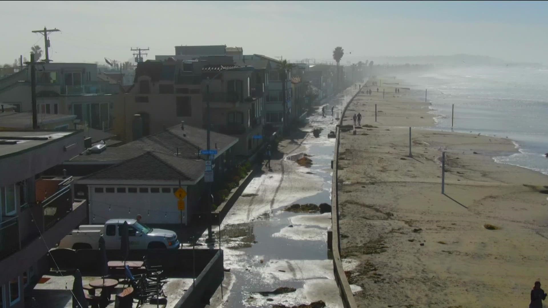
SAN DIEGO — Towering waves flooded much of the San Diego coast Friday morning, leaving ocean-front residents with a huge mess to clean up, and much of Mission Beach Boardwalk turned into a river.
According to the National Weather Service, the system's passage prompted hazardous conditions out on the water.
High surf warnings were issued in San Diego coastal areas, and coastal flood advisories were in effect.
Five rescues between La Jolla and Sunset Cliffs were reported throughout the morning, according to Lifeguard Chief James Gartland.
"These are accomplished expert surfers that either break their leash or they have to pull their leash, they get stuck in a bad area with the high tide people are getting washed in on the rocks and the reefs, so lifeguards are having to go in there, swim them out and get them to a boat and get them to safety," said Chief Gartland.
In Ocean Beach, a woman was rescued by lifeguards after her dog got swept away by rushing water from the San Diego River.
"Lifeguards are up-stuffed, we have jet skis out and patrolling, we have surfboards out and patrolling," he added.
The chief asked people to avoid getting in the water until conditions improved.
"It's not a good day for even avid surfers; you got to be accomplished and good watermen to get out there and negotiate these conditions," said Gartland.
The general rule of thumb is to stay out 72 hours after a storm because of pollution in the water from storm runoff. This suggestion was likely to persist for much of the week due to the storm system which shifted over California.
WATCH: High surf floods Mission Beach boardwalk (January 2023)
A Pacific storm doused Southern California with rain, damaging winds, high surf, and flooding.
Some roadways across the Southland became overrun with water and debris, forcing some freeway lane closures, but the system dropped far less rain Thursday than initially expected as it quickly moved through the area.
The main front of the "bomb cyclone" moved into the area overnight Wednesday. Still, forecasters said the storm traveled much faster than anticipated, which "greatly reduced the amount of rainfall through the area," according to the National Weather Service.
Light to moderate rain fell across most Southland areas Wednesday as residents braced for the brunt of the storm moving across the state.
Strong winds accompanied the rain, prompting a wind advisory in effect through 4 p.m. Thursday in the San Diego County mountains, and from 2 a.m. to 4 p.m. Thursday for coastal and valley areas.
Mountain areas saw 20 to 30 mph winds, with gusts of up to 60 mph. According to the NWS, wind in other areas ranges from 15 to 25 mph, gusting up to 40 mph.
Conditions were expected to dry out Friday and Saturday, with temperatures warming slightly; however, more precipitation is possible in the region by late Saturday night into Sunday.
With the rain, health officials again warned people to avoid entering ocean water near discharging storm drains or rivers due to possible bacterial infection.
Health officials noted that stormwater runoff that reaches the ocean could carry bacteria, chemicals, debris trash, and other health hazards.
Health officials said that people who come in contact with impacted water in the ocean could become ill.
Temperatures were expected to be cool throughout the week, with highs in the 50s and 60s in most areas.