SACRAMENTO, Calif —
A pair of impactful atmospheric river events are slated to slam into California starting Wednesday afternoon.
The cold front will slide across the state on Wednesday and is already bringing heavy rain and very strong wind gusts to the coast of far Northern California.
A strong center of low pressure is currently spinning off the coast of the Pacific Northwest and its associated cold front is tapping into subtropical moisture, hence the use of the term atmospheric river.
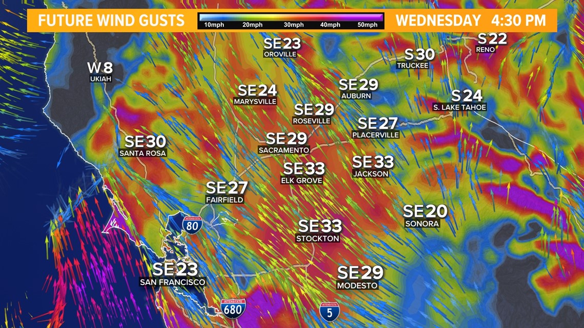
Due to how strong this low-pressure system is, powerful wind gusts will be a concern with this system beginning on Wednesday afternoon and lasting through Thursday morning. A Wind Advisory is in effect on Wednesday, lasting until 6 a.m. Thursday.
Periods of heavy rain beginning Wednesday afternoon have also prompted the issuance of a Flood Watch across the majority of Northern California. A Winter Storm Warning is in effect for the Sierra thanks to heavy snowfall rates and dangerous, if not impossible, travel conditions.
Here’s a timeline of what can be expected as the most powerful storm so far this year arrives.
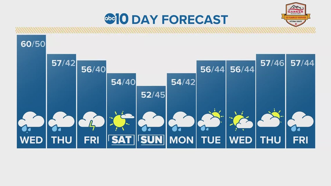
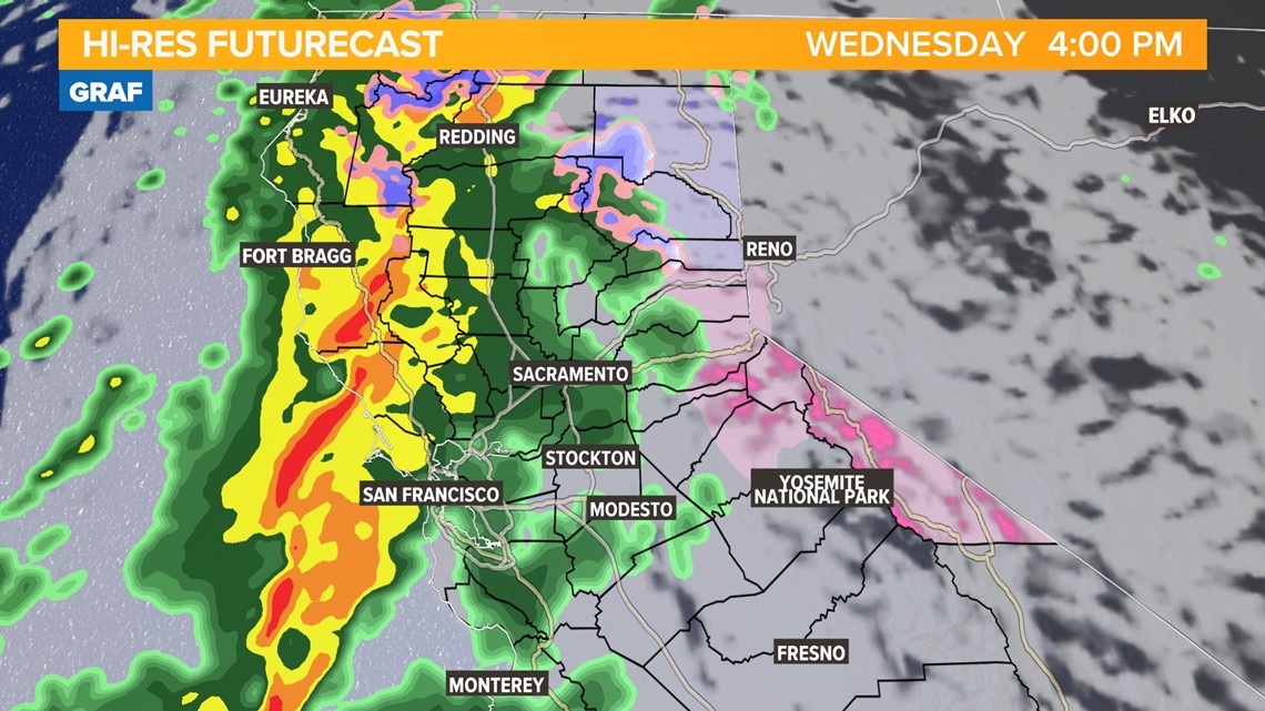
Wednesday afternoon
Rain is expected to pick up in intensity after noon on Wednesday for the northern Sacramento Valley. Further south, in the Sacramento area, heavier rain is expected after 3 p.m.
0.25-0.50" of rain is expected this afternoon.
Snow will begin in the Sierra around 4 p.m. Temperatures ahead of the cold front will remain warm and the snow line will be above 6,000 feet.

Wednesday night
Wednesday night is when the gusty winds will really make their presence felt. Gusts of 40-55 mph are expected in the valley and power outages will be possible due to the likelihood of downed trees and branches.

This will also be the period of heaviest rain in the Sacramento Valley 6 p.m. through midnight will see heavy rainfall rates a the cold front moves over the region. 1-2" is expected in the valley through the overnight hours.
The snow in the Sierra will add up quick with rates of 1-2" per hour possible. Paired with gusts approaching 65 mph, whiteout conditions are expected at times across the mountain passes.


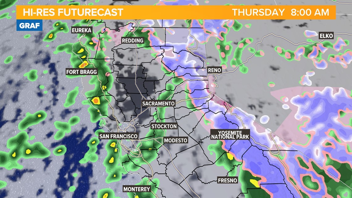
Thursday morning
By Thursday morning Northern California will be behind the cold front and while rain and snow will continue, it won’t be as widespread as Wednesday night. A wet morning commute is still possible depending on where showers pop up.
Snow levels will have dropped by Thursday morning to the 4,000-5,000 foot range.

Thursday afternoon
Thunderstorms are possible Thursday afternoon depending on how much sunshine is able to peak through the clouds following the passage of the cold front. 0.10-0.25" are possible on Thursday with higher totals where thunderstorms develop.
Otherwise, expect periods of rain and snow throughout the day. High temperatures will be in the upper 50s in the valley, 40s and 50s in the foothills, and 30s in the Sierra.
Friday
Isolated showers will continue in the valley on Friday along with more snow in the Sierra. Snow levels will be much lower and snow is possible as low as 3,000 feet on Friday. More thunderstorms are possible as well.
By Friday, valley locations are expected to see 1-3" of rain and 1-2 feet of snow in the Sierra.

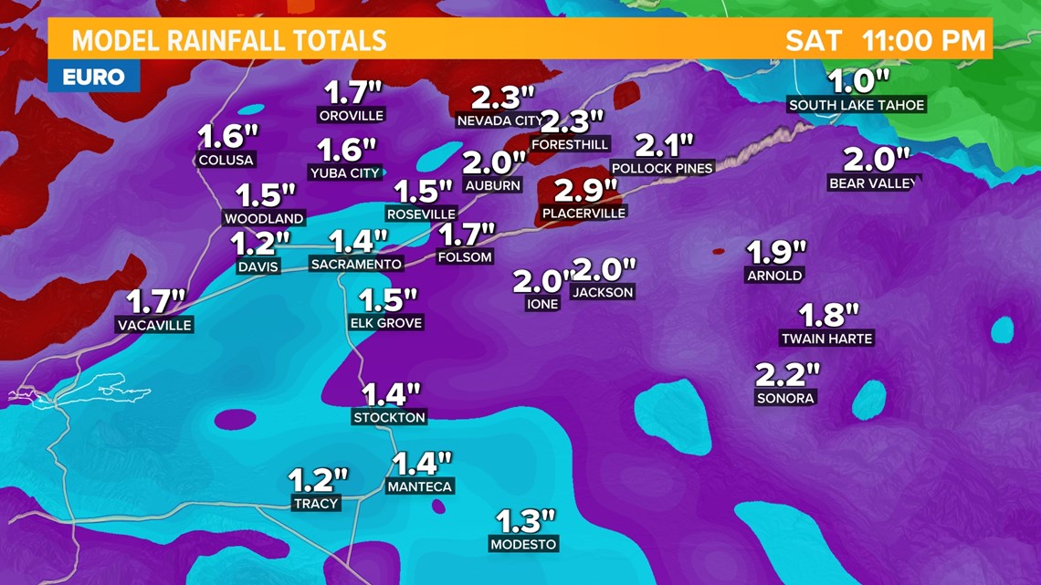
Saturday
Saturday will act as a break between systems. High temperatures will still be on the cool side with highs expected to be in the low to mid 50s in the valley and 30s in the Sierra.
Sunday
The 2nd storm of the series will begin to impact Northern California by Sunday.
This will be the cooler of the two storms and more heavy rain and snow is expected but uncertainty remains in totals at this point.