SACRAMENTO, Calif —
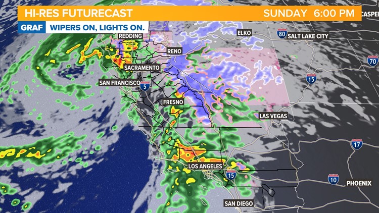
Heavy snow, periods of heavy rain, very gusty winds on Sunday as the strongest atmospheric river storm so far this winter arrives.
The storm arrived overnight, and rainfall totals are approaching an inch east of Interstate 5. A band of heavy rain pushed through communities west of the Interstate and Woodland has already surpassed 4” of rain.
Winds are beginning to pick up in the valley but the strongest gusts aren’t expected until the afternoon. Winds are generally in the 30-40 mph range as of 1 p.m. but widespread gusts nearing 60 mph are possible later today. Along the coast, Point Reyes recorded a gust of 87 mph and Travis Air Force Base had a wind gust of 63 mph.
Rain will continue on and off today but somewhat of a break is expected this afternoon. Heavy mountain snow will continue throughout the day.


Thunderstorms are possible this afternoon and evening and Monday afternoon and evening, and NWS Sacramento places the odds of development at 20-35% in the Delta, valley, and foothills.
Here's a list of the active watches, warnings, and advisories issued by NWS Sacramento:
A High Wind Warning is in effect from Saturday night to Sunday across the valley. The wind forecast has picked up. We're now expecting sustained southerly valley winds of 25-45 mph on Sunday, with gusts of 50-60 mph in the valley. This kind of wind is more than enough to cause smaller and newer trees to fall, large branches to break, and power lines to be blown over. Power outages may be an issue today so make sure to keep your devices charged and have a working flashlight nearby as well.
A Flood Watch is in effect from Sunday to Tuesday. Mudslides and rockslides are possible in the foothills. Flood-prone areas, urban areas, roads, parking lots, and small creeks could flood. Rivers will be running high, even compared to where we've been.
A Winter Storm Warning is in effect until Tuesday for the Sierra. 1-3 ft of snow is possible in the Coastal Range and 4-6 ft possible in the Sierra. Wind gusts of 55 mph or higher are expected.
Live updates:
2:30 p.m. - Sacramento Executive Airport receives 56 mph gust, over 74,000 now without power in Sacramento County.
2:11 p.m. - Sacramento County outages increase to over 38,000 as thousands lose power in Elk Grove.
1:51 p.m. - Over 23,000 without power in Sacramento County.
1:46 p.m. - Over 8,000 SMUD customers and 110,000 PG&E customers without power.
1:14 p.m. - Power outages becoming more widespread in the Sacramento area.
12:59 p.m. - Wind gusts increasing in the Sacramento area.
12:28 p.m. - Gust of 63 mph reported at Travis AFB.
11:38 a.m. - Heavy snowfall rates at the Central Sierra Snow Lab.
WATCH ALSO: