
SACRAMENTO, Calif. — Monday felt like a sneak peek of spring for many in Northern California before the coldest air of the year moves in later this week.
Sacramento reached 68 degrees under sunny skies and calm winds. The warm temperatures made it difficult to envision the incoming cold that will start to move in overnight.
The shift between weather regimes is perhaps most shocking in Redding where it will go from a daily record high of 80 degrees on Monday to accumulating snow by Wednesday night.
Gusty winds Tuesday afternoon will signal the incoming Canadian air associated with a low pressure system. The cold air from western Canada will drop snow levels rapidly and areas unaccustomed to snow could see some Thursday morning.
The forecast is holding tight for now and snow levels look to drop to around 500-1,000 feet by Thursday morning. Areas below that could see a few snowflakes mixed in with the rain if showers pop up overhead and temperatures are cold enough to allow for this to happen.
Temperatures aloft (above the surface) will be cold enough to support snowfall. In fact, the majority of precipitation begins its journey to the Earth's surface as snow before encountering warmer air closer to the surface.
The vertical profile of the atmosphere doesn't show any temperature inversions (where temperature increases with height) in the atmosphere, so frozen precipitation will stay frozen as it falls.
Thursday morning temperatures at the surface will be a few degrees above freezing in the Sacramento area, Stockton and Modesto, and surrounding valley areas south of the Sutter Buttes. The 6 a.m. temperature in these areas looks to be around 33-35 degrees, cold enough for snow to remain mostly frozen but to melt on impact with the ground. Any snow falling below 500 feet will still likely be mixed with rain.
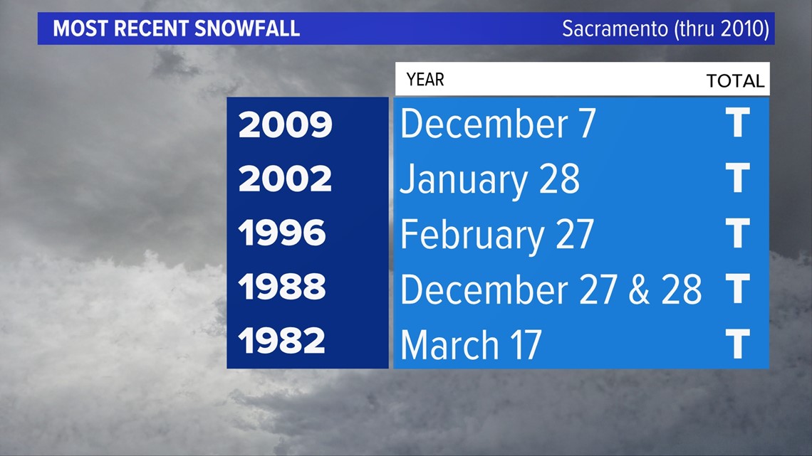
It takes nearly perfect conditions for snowfall to come to fruition in the low lying Central Valley. Sacramento hasn't seen snowfall since 2009.

According to the latest model runs, shower activity appears very limited Thursday morning across the valley. Currently, Sacramento has less than a 10% chance of seeing any mixed precipitation early Thursday morning. These chances raise slightly as you head closer to the foothills, but are still very limited.
Areas lucky enough to have showers overhead are obviously the areas that will have the greatest chance to see snowflakes falling from the sky. Friday morning appears to be slightly warmer, so a cold rain is likely for most of the areas discussed earlier.
The possibility of a stray snowflake remains, however, and as Thursday and Friday morning draw closer there will be a better understanding of what areas have the best chances.
WATCH MORE ON ABC10 | California Drought: The Colorado River crisis and water shortage


