
SACRAMENTO, California — Northern California is fresh off its first snowfall of the year across the Sierra and with El Niño conditions present in the Pacific, optimism is growing that California is due for another wet, snowy winter.
El Niño conditions are typically associated with a wetter than normal wet season in California, particularly the further south you go.
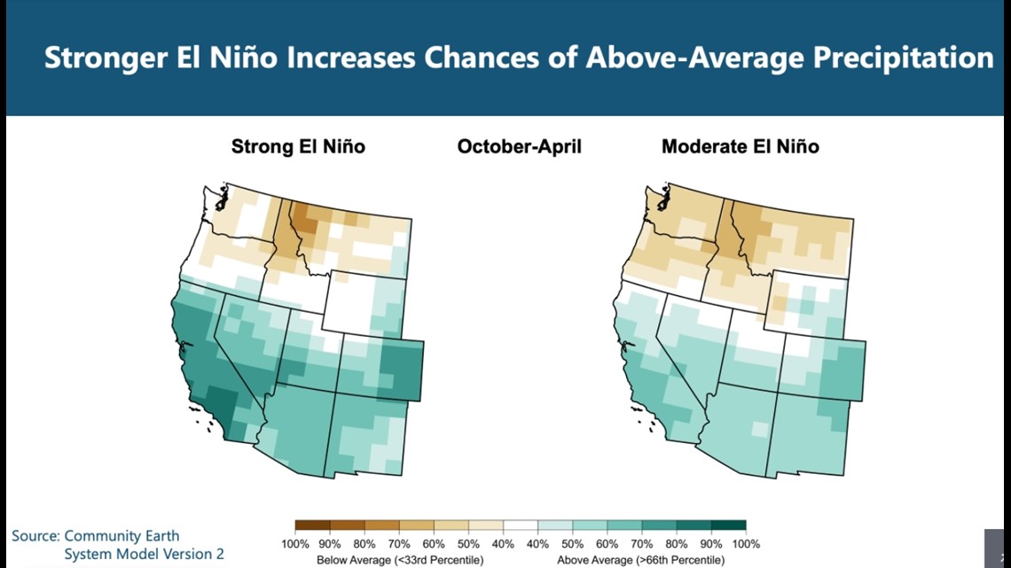
Not every El Niño is the same, though. The strength of the El Niño event plays a vital role in exactly how wet the winter will be, according to Andy Hoell, a research meteorologist at the NOAA Physical Sciences Laboratory in Boulder, Colorado.
"Strong El Niño events have a pretty big effect historically on precipitation in California and the general southwestern United States. Moderate events do as well, but don't have as much of an effect," said Hoell.
An El Niño event meets the strong threshold once waters in the Pacific reach 1.5 degrees C above normal. This is forecast to occur in the coming months, peaking in December or January.

Not only does the strength matter, but so does the “flavor” or positioning, according to Hoell.
Some El Niños are more eastern-based, meaning the warmest sea surface temperature anomalies are concentrated near the South American coast, while others see the warmest anomalies more towards the central Pacific. These events are known as Modoki El Niños.
“When it comes to California, the strong El Niño events tend to be the eastern Pacific El Niño events. Those tend to have a greater effect on California than, say, the central Pacific (Modoki) events,” said Hoell.
Even though there is historical precedent that a strong El Niño results in wet conditions across the state, long-range climate models aren’t exactly on board with that.
"The forecast models that we use to make seasonal predictions, they are really showing some pretty meager chances in the probability of above average precipitation. This isn't exactly what we would expect out of an El Niño event of this magnitude," said Hoell.
The models Hoell was hinting at include the NMME (North American Multi-Model Ensemble) and the European, which both hint at near to above-average rainfall this winter but not on the level that typically comes with a strong El Niño.


The NMME in particular favors drier-than-normal conditions through the end of the year before the rain and snow ramp up after the new year and continuing through March.
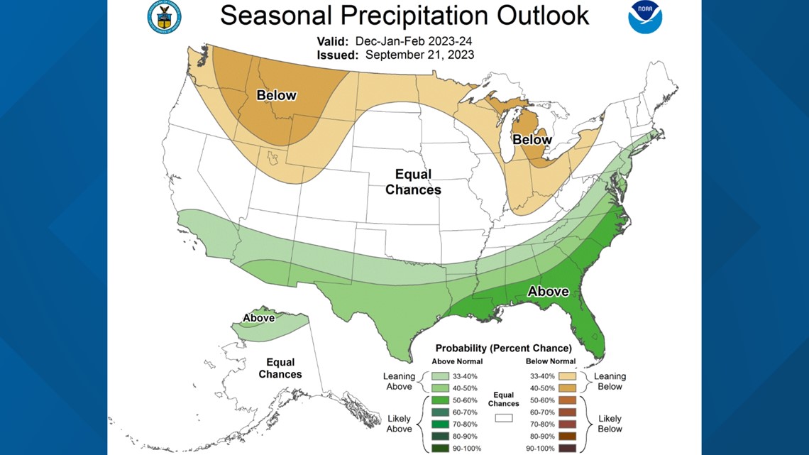
The Climate Prediction Center's outlook for December through February shows equal chances of above-average or below-average precipitation in Northern California, but Southern California is shaded in light green.

Winter precipitation patterns are based on much more than just El Niño and even usually drier La Niña winters can turn out to be extremely wet, as was the case last year. Other atmospheric teleconnections, such as the Madden-Julian Oscillation or the Pacific North American Pattern, play a vital role in the weather pattern.
Seasonal forecasting models are improving every year and have insights that human forecasters don't have, so their data can't be entirely discarded. Still, the strong historical precedent of Northern California being wetter than normal during a strong El Niño leads Hoell to believe California has a good shot at seeing another wet winter.
"I think we have an elevated chance of above-average precipitation across the state. Certainly more of an elevated chance, the further south you go because of historical relationships we've seen with El Niño and California precipitation," Hoell said, "but as we've seen in the past, when we only see a 40-50% odds of above average precipitation, we still have a 50% chance of average or below average precipitation."
Even if Northern California ends up having a below-average winter, data dating back to 1950 shows that the lowest percent of average in the Sacramento River watershed region is 75% during a strong El Niño year.