
PLUMAS COUNTY, Calif. — ---
Thursday's updates are at /article/news/local/wildfire/dixie-fire-evacuations-maps-updates-aug-5-2021/103-3c4a14cb-c52c-4029-bdba-2f44c278e699
---
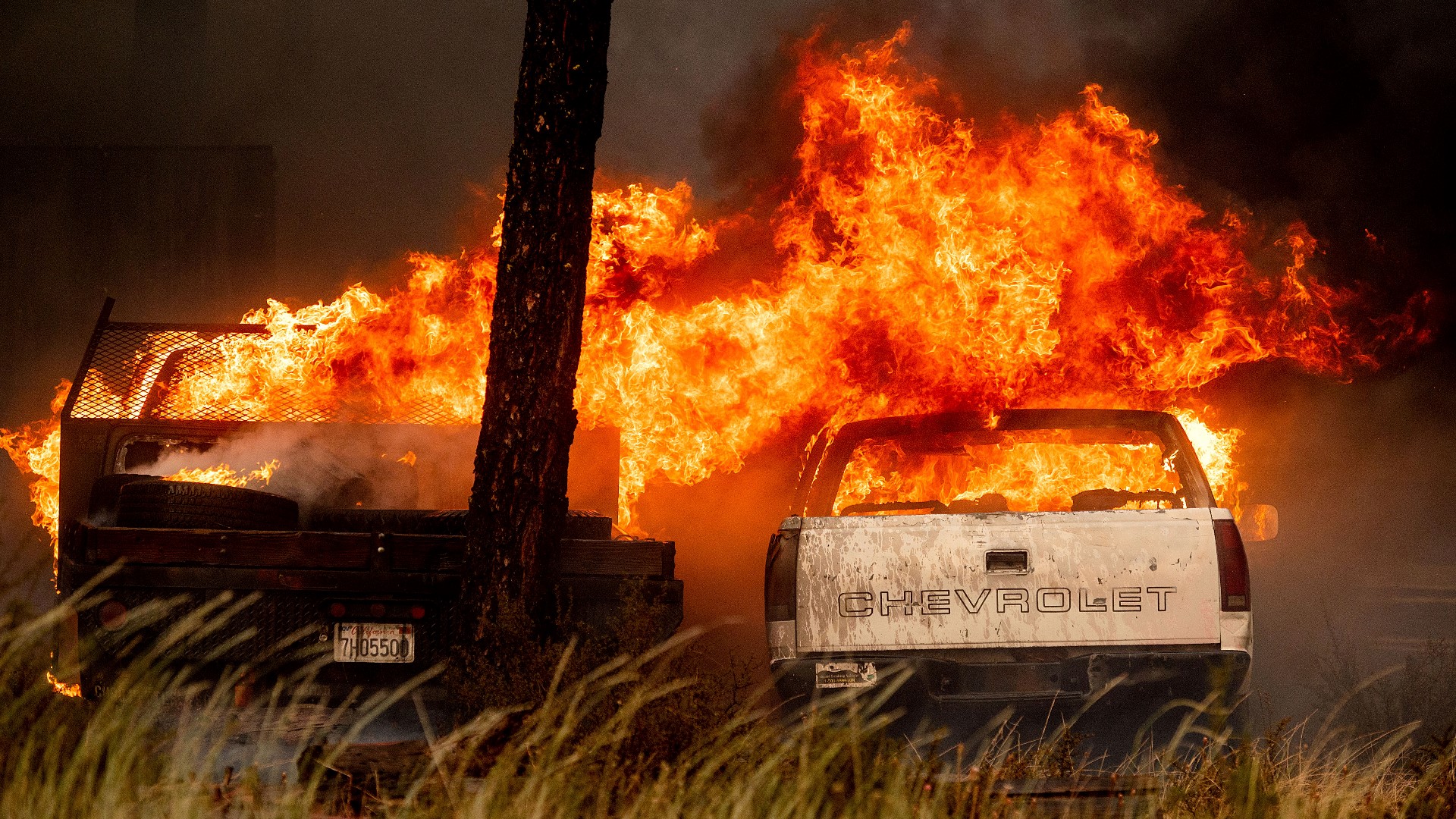
The Dixie Fire tore through the Greenville on Wednesday evening, destroying businesses and homes as the sky was cast in an orange glow.
A photographer on assignment for The Associated Press described seeing a gas station, hotel and local bar burned to the ground in the town of 800 people.
Greenville residents were told to evacuate south to Quincy. Residents who remain were warned that emergency responders may not be able to reach those who ignore this warning. Fire officials said crews were fighting for the town of Greenville.
Greenville is in the east zone of the fire, which generally saw active fire due to gusty winds. The fire spotted over control lines into Round Valley drainage and crews are trying to protect structures in the town.
According to Jake Cagle, Operations Section Chief for California Incident Management Team 5, the situation near Greenville escalated around 4 p.m. Wednesday afternoon when the slipped past crews and got into Greenville.
He said crews are trying to protect structures but are also having to remove people from the area who chose not to evacuate.
"It is imperative that you guys listen to these mandatory evacuations. Right now, we can’t protect the structures because we’re trying to get people out of here. Because a lot of people chose to stay in here. This is big problem that we’re having. These are not the normal fires anymore,” Cagle said.
The sheriff’s office had warned residents to get out or seek refuge if they could not safely escape. The Plumas County Sheriff’s Office made one more plea for residents in Chester and Greenville who stayed behind.
The fire has burned a total of 278,227 acres so far but sits at only 35% containment.
Chester residents were told to evacuate immediately to the east. Residents who couldn't safely evacuate were told to try to take refuge at the Chester High School baseball field.
Just after 1 p.m., the Tehama County Sheriff’s Office has issued a new evacuation warning for the Highway 36 east corridor east of the Battle Creek campground to the Plumas County line, to include the community of Mineral, Mill Creek, Childs Meadows, and the Fire Mountain Lodge.
Evacuation warnings are also being issued for Zones C16 and C17, and all subsections in those zones, the sheriff’s office said. All other orders and warnings remain in effect.
Authorities in Lassen County also issued an evacuation warning for the following areas:
- Westwood and Pine Town area south of Hwy 36 from the Westwood Landfill Rd. east to Moonlight Ranch Rd. zone LAS-E023
- Clear Creek, south of Hwy 36 from the Lassen County line east to the Westwood Landfill “haul road”. Zone LAS-E020
Right now all of the evacuations are still in place for Butte, Tehama, Plumas and Lassen counties as well as evacuation orders around Lake Almanor and the Chester area.
About 4,785 personnel are working the fire, Cal Fire announced.
More than 12,438 structures are threatened by the fire, and so far 45 have been destroyed along with 22 minor structures.
For Tuesday's updates, click HERE.
Accounts to follow:
Evacuation orders:
Plumas County
West shore of Lake Almanor from the Canyon Dam, northwest to Hwy 36 at Hwy 89. This includes the communities of Prattville, Big Meadows, and Lake Almanor West along with the Rocky Point Campground and the Canyon Dam Boat Launch.
High Lakes (PLUMAS COUNTY) Recreational area of Plumas County east of the Butte/Plumas County line. Plumas/Butte County line east of Twain includes both sides of Hwy 70 in the areas of Rock Creek, Storrie, Tobin, Belden, Caribou Rich Bar, and Twain.
Meadow Valley and Bucks Lake, Bucks Lake Rd. at Riverdance, and everything west to the Butte/Plumas County Line. This includes Snake Lake, Meadow Valley, Tollgate, Bucks Lake, Bucks Lake Highlands, and all surrounding areas.
Caribou Rd. north to Humbug Rd. and Humboldt Rd. intersection. This includes Belden Reservoir and Butt Valley Reservoir, Prattville, Butt Reservoir Road, and everything west to the Butte/Plumas County line, and the community of Seneca south to Hwy 70.
High Lakes area, Storrie, Tobin, and Rock Creek. Evacuation Order for Belden, Rich Bar, Virgilia, Seneca, and Twain communities along the SR70 corridor. Evacuation Order to begin at SR70 at Pulga Rd. along the north edge of the SR70 corridor to Rich Bar Rd. from SR70 at Rich Bar Rd. to the north along the Pacific Crest Trail to the Plumas/Butte County line from the Plumas County/Butte County line west along the county line to the intersection of SR70 and Pulga Rd.
Meadow Valley and Buck Lakes communities. This area includes the south edge of the SR70 corridor from Belden east to Twain, south from Twain to Snake Lake Rd. at Bucks Lake Rd., to include the communities of Spanish Ranch and Meadow Valley, from south on Bucks Lake Rd. at Snake Rd. to the intersection of Bucks Lake Rd. and Big Creek (south), from the intersection of Bucks Lake Rd. and Big Creek Rd. (south) along Bucks Lake Rd. to the Plumas/Butte County line, from Bucks Lake Rd. at the Plumas/Butte County line to the north, along the Plumas/Butte County line, where it intersects with SR70 at Pulga Rd.
Caribou area. Evacuation to include SR70 at Virgilia to the north along the east shore of Butt Valley Reservoir, to the intersection of Humbug Rd. and Humboldt Rd, to the east along Humbug Rd. to the Butte Co. line, to the south along the Butte Co. line to Chips Creek, east along Chips Creek to SR70, east along the north edge of the SR70 corridor to Virgilia.
Paxton, Seneca, Long Valley, and East Butt Lake area. Evacuation Order to include the Paxton area at SR70, north to the Long Valley, west to the south side of Butt Valley Reservoir, from the south side of Butt Valley Reservoir to SR70 at Virgilia, east along the north edge of the SR70 corridor to Paxton.
Long Valley and Seneca Communities starting from the Long Valley area north along Wolf Creek Rd., to the intersection of Wolf Creek Rd. and South Almanor, from the intersection of South Almanor and Wolf Creek Rd. west along South Almanor, continuing west along Fox Farm Rd. to the intersection of Humbug-Humboldt Crossing Rd., from the intersection of Fox Farm Rd. and Humbug-Humboldt Rd., to south along Prattville, Butt Valley Reservoir Rd. to the south shore of Butt Valley Reservoir, from the south shore of Butt Valley Reservoir east to Long Valley.
Community of Prattville, which includes north of SR89, south of Lake Almanor, west from Canyon Dam and east from Humboldt Rd.
Community of Canyon Dam. Starting at the intersection of SR89 and SR147 east to the intersection of SR89 at Old Haun Rd., from the intersection of SR89 and Old Haun Rd. north to the intersection of Old Haun Rd. and SR147, from the intersection of SR147 and Old Haun Rd. to the intersection of SR89 and SR147
Almanor West community. PLU-5B will begin at the intersection of Humbug Humboldt Cross Rd. at SR89, north along SR89 to south along the west shore of Lake Almanor to Osprey Rd., west along Osprey Rd. and continuing west along Humbug Humboldt Cross Rd. to the intersection with SR89
Humbug Rd. from the intersection of the Humbug-Humboldt Rd. west to the Butte County line and everything south of the Humbug Rd. to Humboldt Rd.
Beginning from the intersection of Humbug-Humboldt Crossing Rd and Fox Farm Rd, west along Fox Farm Rd to the intersection with SR36, south from the intersection of SR36 and Fox Farm Rd, south to the Butte County line, south along Butte County line to Humboldt Rd., east along Humboldt Rd to the intersection with Humbug - Humboldt Crossing Rd, continuing west to the Butte County Line, south along the Butte County Line to Humbug Rd, east along Humbug Rd to the intersection of Humboldt Rd.
Begin at the intersection of Humbug Humboldt Cross Rd. at SR89, south along Humbug Humboldt Rd. to the intersection with Humboldt Rd., west to the Round Valley Creek and Deer Creek intersect, north along the Tehama County Line to the intersection SR36, east along SR36 to the intersection of SR89, south along SR89 to the intersection with Humbug Humboldt Cross Rd.
Community of Stover. This will include the intersection of SR89 at SR36, west SR36 to the Pacific Coast Trail, north to Willow Springs Camp Ground, northeast to the intersection of Old Red Bluff Highway and Warner Valley Rd., south to the intersection of SR89 and SR36.
Community of Chester. This includes the intersection of Old Red Bluff Highway and Warner Valley Rd., east to Last Chance Camp Ground, south to SR36 on the causeway, southwest to the intersection of SR89 and SR36, north to the intersection of Old Red Bluff Highway and Warner Valley Rd.
Communities of Peninsula and Hamilton Branch. The warning will include SR36 on the causeway, east to the Lassen County Line, south on SR147 to County Road A13, south to Peninsula Point, north to the SR36 causeway.
Community of East Shore. The Order will include the intersection of SR147 and County Rd. A13, east to Little Dyer Mountain, southeast to Dyer Mountain, south to SR89, west to SR147, north to County Rd. A13.
Community of Round Valley Reservoir and Long Valley will include SR89 near the Clear Creek to the SR70, south to SR70 at the Feather River, east along SR70 to the intersection of SR89, north on SR89 to Dixie Creek due north to Seltzer Rd.
Community of Round Valley Reservoir and Long Valley. This includes SR89 near Round Valley Reservoir and west along Long Valley Rd., to Dixie Creek and north to SR89.
Community of Butterfly Valley. The Order will include Feather River Hot Springs east on SR70 to Barlow Road, southwest to Oroville-Quincey Highway, west to Snake Lake Road, north to Feather River Hot Springs.
Community of Butterfly Valley. The Evacuation Order is to begin at Blackhawk Rd at SR70, to west on Snake Lake Rd to the intersection with Powerline Easement, continuing west from the intersection of Snake Lake Rd and Powerline Easement to the Hambly Ravine, from the Hambly Ravine north to SR70, continuing east along the SR70 Corridor to the intersection with SR89 (Greenville Wye), from the intersection with SR70 and SR89 (Greenville Wye), continuing east along the SR70 corridor to the intersection with Blackhawk Rd.”
Community of the northeast side of Indian Valley. The Order will include Dyer Mountain, southeast to Keddie Ridge, southeast to Diamond Mountain Road, west to Stampfli Lane, north to Wolf Creek, northwest to the intersection of N Valley Road and Pecks Valley Road, north to the intersection of Williams Valley Road and Lower Williams Valley Road, northwest to SR89 at Second Water Tower Creek, north to Dyer Mountain.
Community of Greenville and Crescent Mills. The order will include SR89 at Dixie Creek, northeast to Stampfli Lane, north to Wolf Creek, northwest to SR89, north on SR89 to Hauns Creek.
Community of Taylorsville. The order will include SR89 at Moccasin, northeast to Stampfli Lane at Indian Creek, east to Diamond Mountain Road, south to Genesee Road at N Valley Road, west to SR89 at Indian Falls, northeast to Moccasin.
Mount Hough. The order will include SR89 at Indian Falls, east to Genesee Road at N Valley Road, south to the intersection of Forest Service Road 25N14 and Forest Service Road 24N85, west to SR70 at Barlow Road, north to SR89 at Indian Falls.
Areas north of Chandler Road. Chandler Road at Oakland Camp Road east to State Route 70, north from the intersection of State Route 70 to the south border of Canyon Railroad Subdivision. The northern borders of Zones 17 and 17A are moved to the south edge of Chandler Road and remain in Evacuation Warning status.
Peter’s Creek Area. The Order begins at Taylorsville Rodeo Grounds north to Keddie Park, continuing north along Cook’s creek to Springs Creek, east to Enlge Mine, south from Engle Mine to Peter’s Creek, continuing south along Peter’s Creek to Taylor Diggings, west from Taylor Diggings to Talyorsville Rodeo grounds.
Echo Lake. This includes the area north of Hwy 36, north to the county line, and east of Chester, east to the county line.
Evacuation Order for the Swain area.
Evacuation Order for the area of Warner Valley.
Evacuation Order for the area Sifford
More information on evacuations can be found on the Plumas County Sheriff's website.
If anyone needs transportation out of the mandatory evacuation area, call 530-283-6414.
Butte County:
- Jonesville area
- Lake Philbrook area
- Butte Meadows
Tehama County:
- TEH-1 (D18, D19, E18, E19) Evacuation Order for the St. Bernard’s Lodge and Elam-Carter Creek areas
- Area of Wilson Lake
- East of Wilson Lake, to the Tehama/Plumas County line
Lassen County:
- LAS E019 Evacuation Order This includes the area south of Mountain Meadows Reservoir from Hamilton Branch waterway east to the Lassen/Plumas County line.
Evacuation warning
Plumas County Sheriff's Office removed some of the evacuation warnings in the county. Click HERE for the updated list of evacuation orders and warnings.
Plumas County:
- Community of Taylorsville. This will include SR89 at Moccasin, northeast to Stamfli Lane at Indian Creek, east to Diamond Mountain Rd., south to fire perimeter south of Arlington Rd. continuing to Moccasin.
Areas from the intersection of Chandler Rd. (east) and SR-70 east to Oakland Camp Road and south of Mount Hough Rd.
Peter's Creek area. This begins at Taylorsville Rodeo Grounds north to Diamond Mountain Rd. Follows diamond Mountain Road to Engle Mine, and south from Engle Mine to Peter's Creek, continuing south along Peter's Creek to Taylor Diggings, west from Taylor Diggins to Taylorsville Rodeo Grounds.
Little Grizzly Creek. The order will begin at intersection 25N14 and 24N85, east to the intersection of Gaging Station, south to 25N14 and 24N85.
Genesee Valley. This includes east of Taylorsville along Genesee Rd corridor continuing east along Genesee Indian Creek and ending at 27N09.
Butte County:
- Inskip area
Tehama County:
- Evacuation Warning for the Wilson Creek and Slate Creek areas
- Area of Fire Mountain Lodge. This will include subzones 221, 222, 223, 224,225, 226, 228
- Area of Childs Meadows/Highlands Resort. This will include subzones 228 and 227
- Area of Colby Creek. The order will begin at the Butte and Tehama County line, west along the Tehama County Line to the intersection with SR32, north along the SR32 corridor to the intersection with SR36, from the intersection with SR32 and SR36, east along SR36 to the intersection with Plumas and Tehama County Line.
Lassen County
- Clear Creek, south of Hwy 36 from the Lassen County line east to the Westwood Landfill “haul road”. Zone LAS-E020
Evacuation centers
- Spring of Hope Church, 59 Belle Lane Quincy, CA 95971
- run by the American Red Cross California Gold Country Region
- Plumas County Animal Services, 201 N Mill Creek Rd Quincy, CA 95971
- Veterans Memorial Hall at 180 Gay St. in Chester, CA
- Lassen Community College at 478-200 CA-139 Susanville
- Plumas County Fairgrounds 204 Fairground Road, Quincy (large animals)
- Recreation Center 101 Meadowview Lane, Chester
- Tehama County Complex 1830 Walnut Street, Red Bluff (large and small animals)
Road Closures
Plumas County
- SR70 at West Chandler Rd – No WB SR70 and No NB Chandler Rd
- SR70 at SR89 (Greenville “Y”)-No WB SR70
- Bucks Lake Rd. at Lower Big Creek Rd.
- SR36 at SR89-no WB SR36 traffic-no SB SR89
- CA147 at SR89
- Bucks Lake Rd. at River Dance-No SB Bucks Lake Rd.
- SR147 at A13-No SB147
- A13 at SR36
- SR89 at Stampfli-No NB SR89
- SR70 at Deadwood Rd – No EB SR70
- SR32 at Humboldt Rd.-No EB Humboldt Rd.- No NB SR32 Traffic
- Skyway at Humbug Summit Rd.-No NB Skyway-No EB Humbug Summit Rd.
- SR32 at SR36-no SB SR32 traffic/no EB SR36 traffic
For current State Highway/Route information visit roads.dot.ca.gov
Butte County Evacuation Map
A live evacuation map from Butte County is available below.
Wildfire Map
An updated map of the acreage of the Dixie Fire
WILDFIRE PREPS
According to Cal Fire, 2020 was one of the most severe fire seasons on record as 9,917 wildfires burned 4.2 million acres. Over 9,000 structures were destroyed, and 31 people (civilians and firefighters) were killed.
California also experienced its first "Gigafire" because of the August Complex Fire, burning over 1 million acres by itself. Four of California's top five largest wildfires in state history happened in 2020.
If you live in a wildfire-prone zone, Cal Fire suggests creating a defensible space around your home. Defensible space is an area around a building in which vegetation and other debris are completely cleared. At least 100 feet is recommended.
The Department of Homeland Security suggests assembling an emergency kit that has important documents, N95 respirator masks, supplies to grab with you if you’re forced to leave at a moment’s notice. The agency also suggests signing up for local warning system notifications and know your community’s evacuation plans best to prepare yourself and your family in cases of wildfires.
Some counties use Nixle alerts to update residents on severe weather, wildfires, and other news. To sign up, www.nixle.com or text your zip code to 888777 to start receiving alerts.
PG&E customers can also subscribe to alerts via text, email, or phone call. If you're a PG&E customer, visit the Profile & Alerts section of your account to register.
WATCH MORE FROM ABC10: Lightning strikes causing fires, bear burned in Tamarack Fire recovering and more