
SOUTH LAKE TAHOE, Calif — Click HERE for Thursday's Caldor Fire story.
As the fight against the Caldor Fire stretches on, officials are allowing some communities in the area of North Camino and Pollock Pines to head back home.
In a news release, officials downgraded mandatory evacuation orders to warnings for the following areas: North of Highway 50, West of Sly Park, South of Slab Creek, and East of Larsen Drive / Snows Road.
"As you are repopulating the area, please call EDSO to report any suspicious or criminal activity. EDSO and our allied agency partners are maintaining significant resources in the area. Thank you and be safe," the El Dorado County Sheriff's Office said on Facebook.
The El Dorado Irrigation District requested people run their internal taps for a couple minutes before returning to ensure fresh water in their homes.
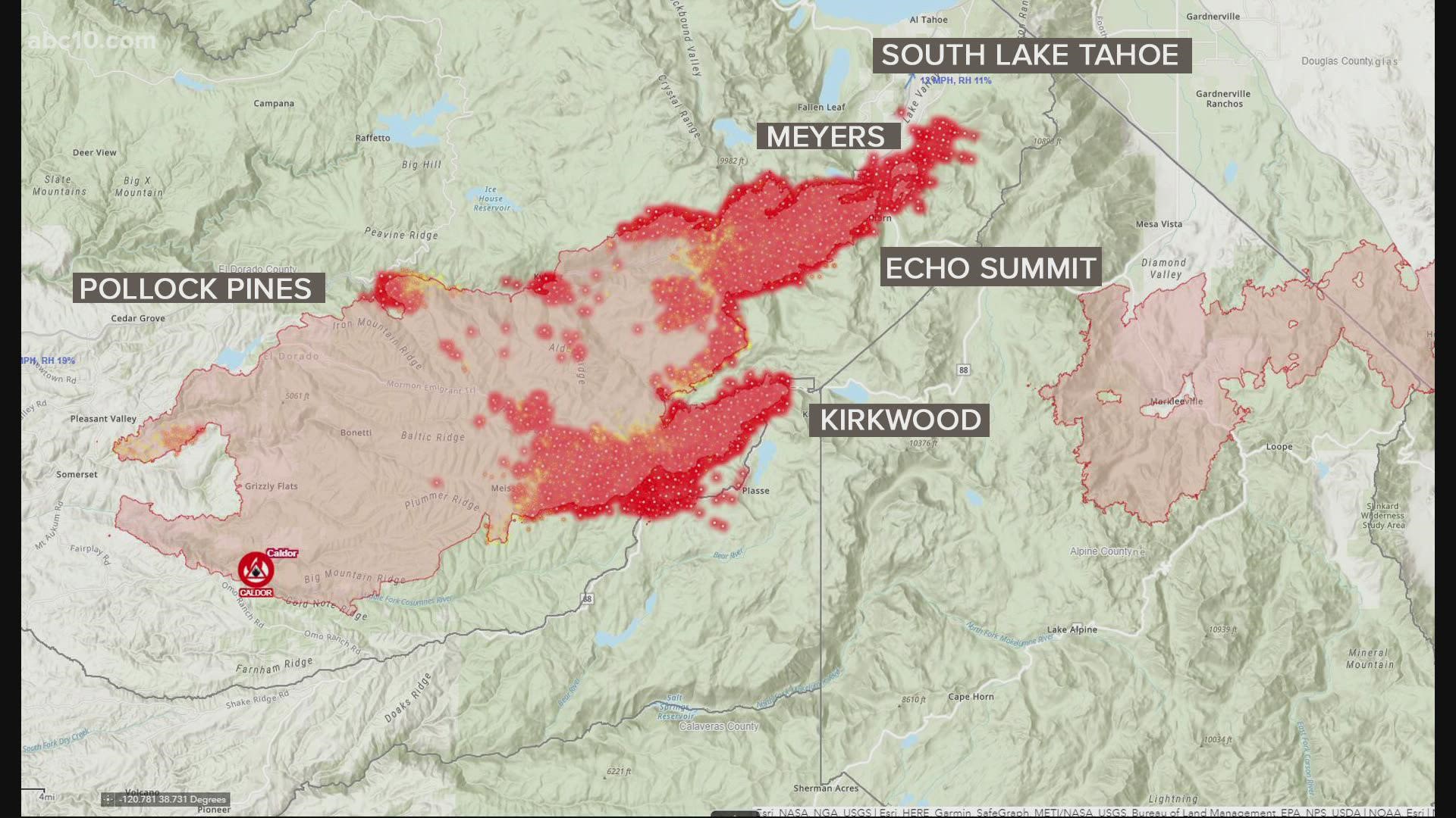
However, the firefight in other areas of the fire is not done yet. CHP-Truckee said Highway 89 was closed in both directions at the El Dorado/Placer county line due the wildfire. Flames also raced across treetops and through drought-stricken vegetation as firefighters scrambled to keep the Caldor Fire from reaching a resort city at the southern tip of Lake Tahoe.
But, fire officials are reporting positive news. Tuesday's winds weren't as strong as expected and lighter winds are expected.
Fire officials said the fire was burning in the hills and slowly making its way down towards the water at Echo Lake early Wednesday morning. However, Jed Gaines, a battalion chief for Cal Fire said what the fire was doing, was a good thing. Gaines said the cabins along the road leading to Echo Lake were still standing, a positive outcome after the fire was seen creeping up the hillsides.
"We're hoping that we can get it up there and just kind of hang it up in some of the granite and sparser fuels, which will allow us, once these winds subside, the red flag warnings go away, will allow us to try and get crews up there, try to go direct and hold it in place." Gaines said.
In an afternoon update, firefighters said the fire was pushing back toward Wrights Lake, but aircraft, dozers, and hand crews are doing what they can to keep the fire from moving west.
Operation Section Chief Beale Monday said the Christmas Valley and South Lake Tahoe areas have heavy resource commitment.
“We’ve got folks from all over the country here pushed into this entire area. Right now, the fire is skirted across the northside of Christmas Valley and is pushed on the east side of pioneer trail,” Monday said.
More firefighting was going on in the Kirkwood area where the fire slopped over Highway 88. Hotshot crews, engines and helicopters are trying to keep the fire in check as they deal with the blaze throwing spot fires toward the community.
Governor Gavin Newsom requested a Presidential Emergency Declaration for the Caldor Fire in an effort to support those impacted by the wildfire and protect the Lake Tahoe region.
“California stands with Lake Tahoe communities and all the residents impacted by the Caldor Fire,” said Governor Newsom. “We are using every available tool to protect lives and property and urge residents to stay safe and remain alert for instructions from local authorities amid these dangerous fire weather conditions.”
Hours later, President Biden approved the declaration, and ordered federal assistance to help California's response to the wildfire.
The Caldor Fire has grown to 207,931 acres and is 23% contained. Nearly 600 homes have been destroyed and nearly an additional 35,000 remain threatened. More than 53,000 people have been evacuated so far because of the fire.
The fire is named the Caldor Fire, after the road where it started on Aug. 14 near the community of Grizzly Flats. That is about 35 miles from Lake Tahoe. The fire as of Tuesday morning spanned about 300 square miles, with nearly 4,000 firefighters trying to stop it.
Here's other updates from Wednesday morning that you might have missed:
- The South Tahoe Public Utility District pleaded with residents to turn off hoses and irrigation systems to save water for firefighters.
- A strike team of 16 firefighters was taken from the frontlines after testing positive for coronavirus. Cal Fire spokesperson Jeff Vike said those firefighters will have to quarantine for two weeks.
- South Lake Tahoe launched an evacuation resources page for evacuees.
- The National Weather Service warns critical weather conditions through Wednesday could include extremely low humidity, dry fuel, and gusts up to 30 mph.
Evacuations and Road Closures
Click HERE for in-depth evacuation orders and warnings in El Dorado County. For evacuation orders and warnings in Amador County, click HERE for the Amador County Sheriff's Facebook page and HERE for their website. For current state highway/route information visit roads.dot.ca.gov.
Evacuation centers
El Dorado County Shelters
- Green Valley Community Church, Placerville
- Cameron Park CSD, Cameron Park
- Rolling Hills Church, El Dorado Hills
Nevada County Shelter
- Truckee Veterans Hall, 10214 High St, Truckee
Amador County
- Temporary Evacuation Point Italian Picnic Grounds, Sutter Creek
Nevada State Shelter
- Reno/Sparks Convention Center at 4590 S. Virginia Street, Reno
- Douglas County Community Center, Gardnerville - Douglas County residents only
- Reno Sparks Convention Center
- RV Dry Camping and Large Animals, Dayton Event Center/Rodeo Grounds
- Lyon County Fair Grounds, Yerington
Animal Evacuation Centers:
- El Dorado County Animal Services (small animals), Diamond Springs. For animal evacuation questions or assistance call (530) 621-5795
- Saureel Vineyards (large animals), Placerville - FULL
- Amador County Fairgrounds (large animal)- for Amador County residents only, Plymouth
- Reno Sparks Convention Center Reno - Limited crates and space available for pets.
- Lyon County Fair Grounds, Yerington
- Dayton Event Center/Rodeo Grounds – Dry Camping Only, Dayton
- Douglas County Fairgrounds, Gardnerville
Accounts to follow
Evacuation Maps
A map of evacuations from the El Dorado County Sheriff's Office is available below.
An evacuation map from the Amador County Sheriff's Office can be viewed HERE.
A map of evacuations in Alpine County is available HERE.
Online Structure Damage Map
An online structure damage map is available by clicking HERE or viewing below. To locate your home, type in the address in the top left corner. If you don't see an icon, the structure has not yet been identified.
Wildfire map
Click here for a map of the Caldor Fire.
►Stay in the know! Sign up now for the Daily Blend Newsletter
Wildfire Preps
If you live in a wildfire-prone zone, Cal Fire suggests creating a defensible space around your home. Defensible space is an area around a building in which vegetation and other debris are completely cleared. At least 100 feet is recommended.
The Department of Homeland Security suggests assembling an emergency kit that has important documents, N95 respirator masks, supplies to grab with you if you’re forced to leave at a moment’s notice. The agency also suggests signing up for local warning system notifications and know your community’s evacuation plans best to prepare yourself and your family in cases of wildfires.
Some counties use Nixle alerts to update residents on severe weather, wildfires, and other news. To sign up, visit www.nixle.com or text your zip code to 888777 to start receiving alerts.
PG&E customers can also subscribe to alerts via text, email, or phone call. If you're a PG&E customer, visit the Profile & Alerts section of your account to register.
ABC10: Watch, Download, Read


Watch more
Caldor Fire: Tour of Christmas Valley where the blaze came close to homes | California Wildfire