
Most of the state of California is already looking at rainfall deficits for the 2019 - 2020 winter season.
This has a lot to do with below-average rainfall amounts for the month of January and little to no measurable precipitation, especially in the Sacramento region, during the month of February. Historically speaking, February was the driest since we started taking records in 1849.
BELOW-AVERAGE RAINFALL
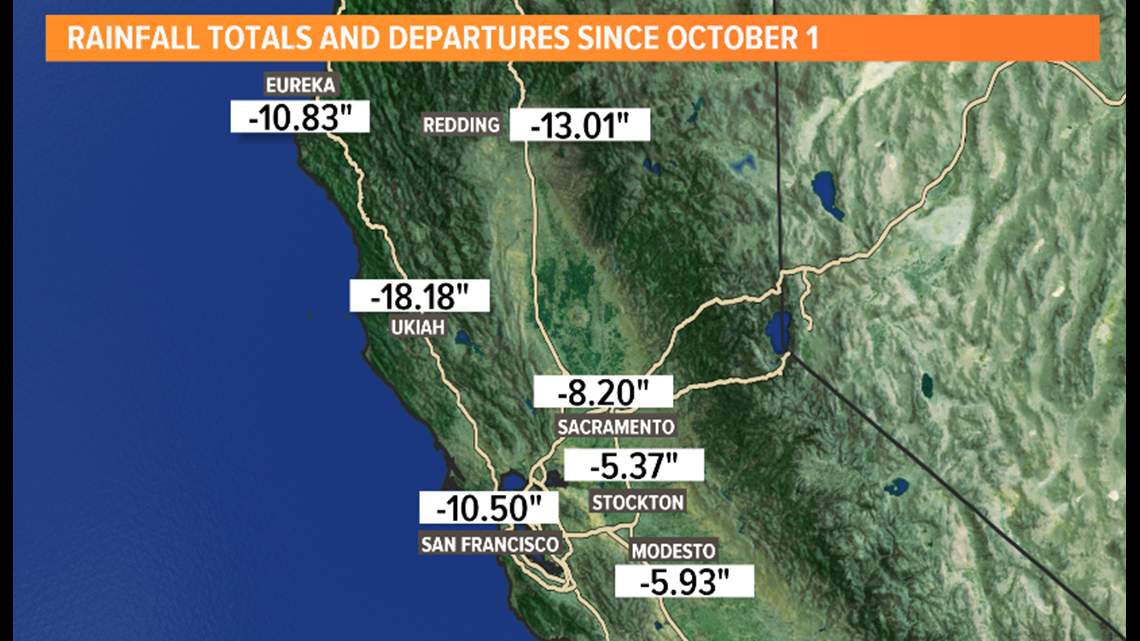
Today, Sacramento Executive Airport is roughly eight inches below average. Stockton and Modesto fare slightly better, at around is five and six inches below average respectively.

DROUGHT CONDITIONS
That being said, it's no huge surprise many locations in the San Joaquin Valley are experiencing drought conditions. Currently, 70% of the state is Abnormally Dry and 34% of the state is in a Moderate Drought. Bear in mind, each day or week that passes with no major rainfall will only exacerbate the dry conditions in our area.
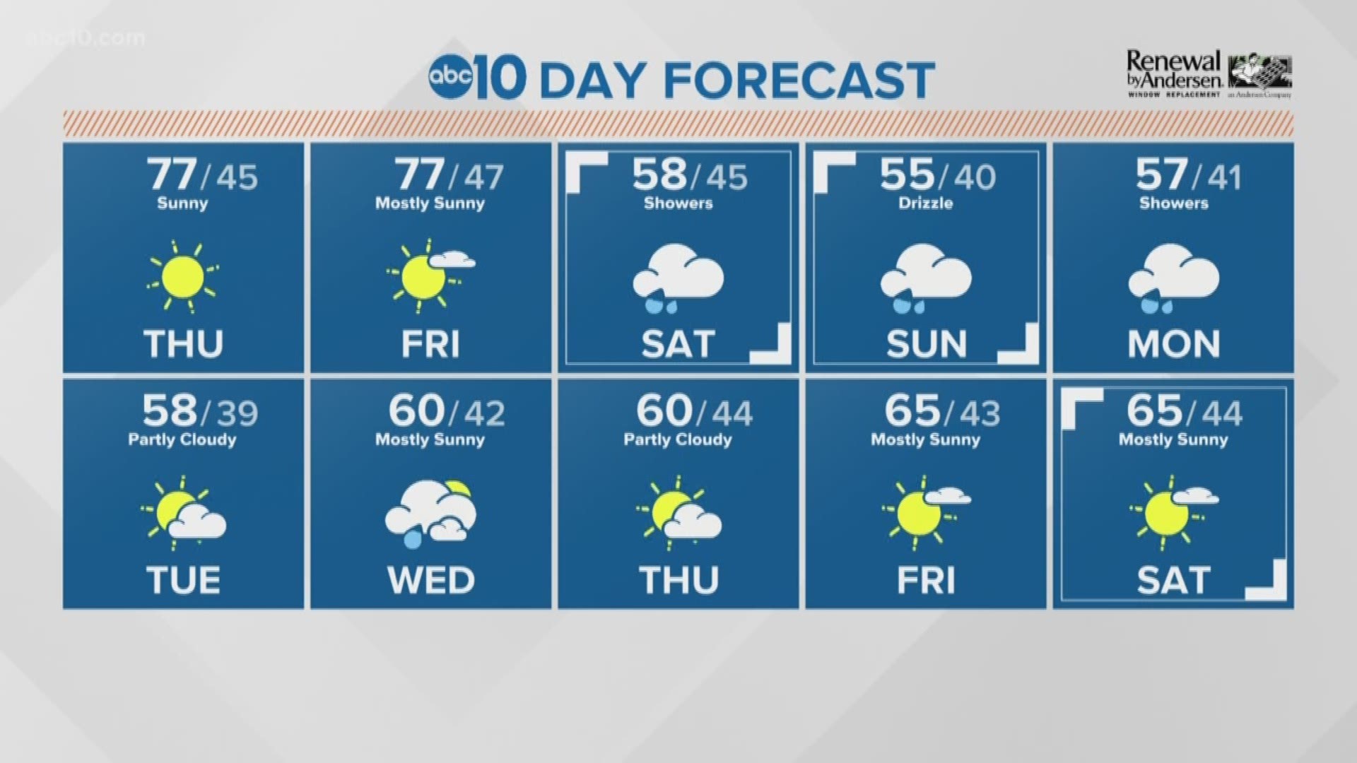
That's why this weekend's chance of rainfall is such a good thing. The latest weather models are showing healthy rainfall amounts for areas south of Stockton from Saturday to Monday night.
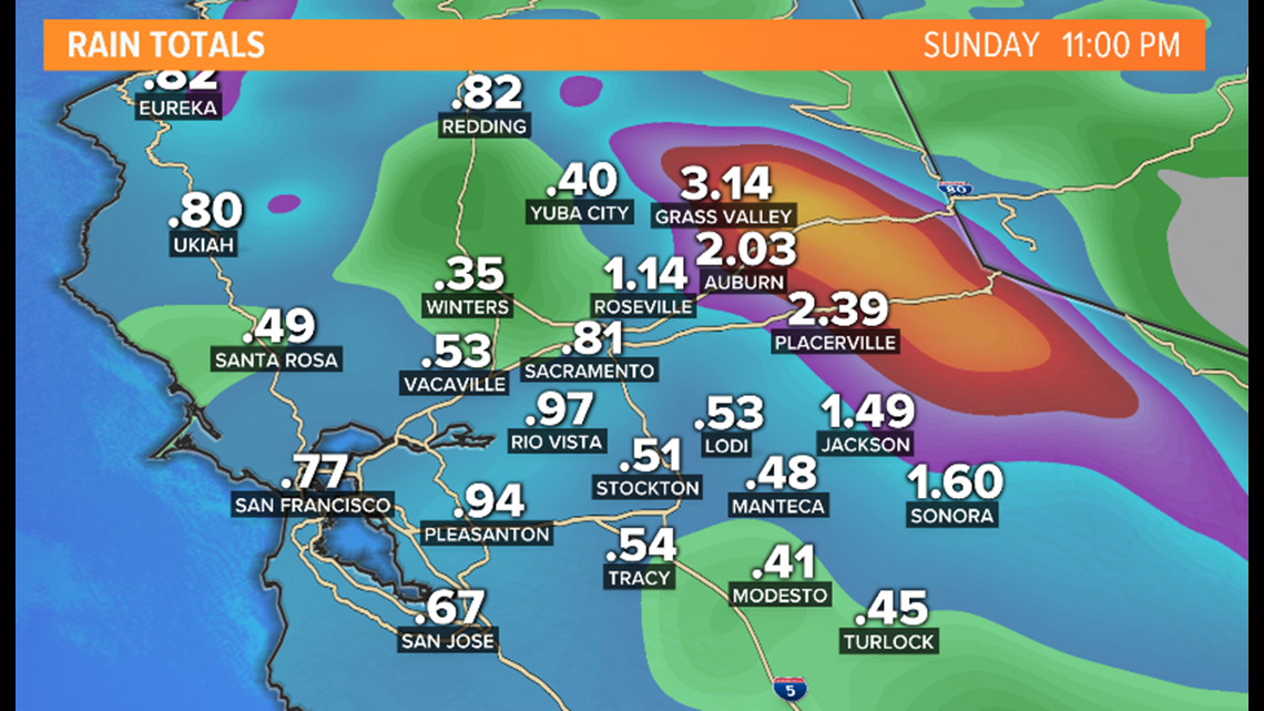
WEATHER FORECAST MODELS PROJECTED RAIN TOTALS, FRI - SUN:
Sacramento - .81"
Stockton - .51"
Modesto - .41"
Turlock - .45"
Auburn - 2.03"
Placerville - 2.39"

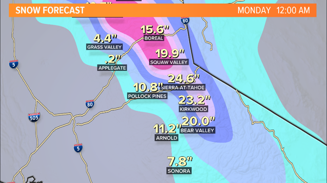
Snowfall amounts look just as promising.
WEATHER FORECAST MODELS PROJECTED SNOW TOTALS, FRI - SUN:
Boreal - 15.6"
Squaw Valley - 19.9"
Sierra-at-Tahoe - 24.6"
Kirkwood - 23.2"
Bear Valley - 20.0"

Weather models are showing the chance of rainfall beginning for the Sacramento Valley, foothills and Sierra Saturday afternoon.
The opportunity for heavier rounds of rain and snow is likely on Sunday. High winds are likely for the Sierra with wind gusts near 50 mph.
Also, the chance of rainfall will remain in the forecast well into next week.
If you're traveling on the roadways over the course of the weekend. Make sure to keep track of the latest weather forecasts. Travel delays are expected along with chain controls in the Sierra.
Keep in mind these rain and snow totals are based on weather model data. If this system speeds up, slows down or changes track it could drastically impact the amount of actual rain and snowfall received as well as the timing of the storm system.
► JOIN THE ABC10 WEATHER FORCE TO GET YOUR PHOTOS ON THE NEWS
► SNOW TRAFFIC: Tahoe Traffic: Live map
► GET WEATHER ALERTS WITH THE ABC10 APP:


► WEATHER IN YOUR EMAIL: Sign up for the Daily Blend Newsletter
► CALIFORNIA WEATHER EXPLAINED: The last drought in California from 2012-16 was so catastrophic, some of the hardest hit communities still haven’t recovered. Can the Golden State get ready in time to make it through the next one before even more towns go under?
► STAY SAFE THIS WINTER:
► MEET OUR WEATHER TEAM: